Druento elevation
Druento (Piedmont, Torino), Italy elevation is 281 meters and Druento elevation in feet is 922 ft above sea level [src 1]. Druento is a seat of a third-order administrative division (feature code) with elevation that is 41 meters (135 ft) smaller than average city elevation in Italy.
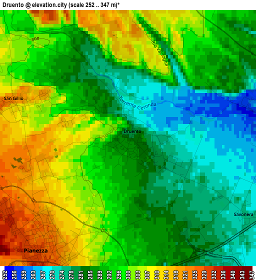
Below is the Elevation map of Druento, which displays elevation range with different colors. Scale of the first map is from 252 to 347 m (827 to 1138 ft) with average elevation of 292.6 meters (=960 ft) [note 1]
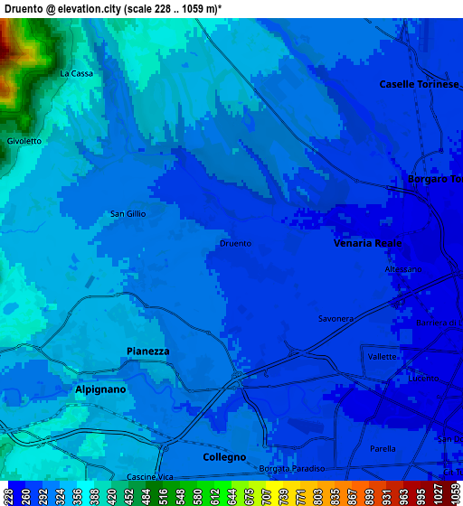
These maps also provides idea of topography and contour of this city, they are displayed at different zoom levels. More info about maps, scale and edge coordinates you can find below images.
| \ | Map #1 | Map #2 | Topo.Map |
| Scale [m] | 252..347 m | 228..1059 m | × |
| Scale [ft] | 827..1138 ft | 748..3474 ft | × |
| Average | 292.6 m = 960 ft | 311.7 m = 1023 ft | × |
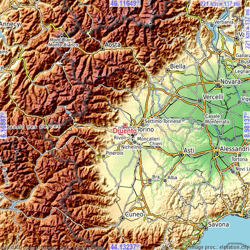
| Width | 6.89 km = 4.3 mi | 13.79 km = 8.6 mi | 220.6 km = 137.1 mi |
| Height | 6.89 km = 4.3 mi | 13.79 km = 8.6 mi | 220.6 km = 137.1 mi |
| ↑Max Latitude | 45.164053° | 45.19503° | 46.11649° |
| Latitude at center | 45.13306° | 45.13306° | 45.13306° |
| ↓Min Latitude | 45.10205° | 45.071023° | 44.13237° |
| ← Min Longitude | 7.531175° | 7.487229° | 6.16887° |
| Longitude center | 7.57512° | 7.57512° | 7.57512° |
| →Max Longitude | 7.619065° | 7.663011° | 8.98137° |
Nearby cities:
Cities around Druento sort by population:
• Collegno elevation 310 m
6.1 km,  185°
185°
• Venaria Reale 263 m
4.5 km,  100°
100°
• Alpignano 339 m
6 km,  222°
222°
• Pianezza 326 m
3.8 km,  211°
211°
• Caselle Torinese 280 m
7 km,  49°
49°
• Borgaro Torinese 257 m
6.6 km,  72°
72°
• Givoletto 440 m
7 km,  297°
297°
• Caselette 373 m
7.5 km,  249°
249°
• San Gillio 322 m
3.4 km,  284°
284°
• Robassomero 364 m
7.3 km,  355°
355°
• Savonera 274 m
3.8 km,  124°
124°
• La Cassa 375 m
7 km,  318°
318°
Multilingual:
 En español:
Druento elevación 281 m.
 En France:
Druento élévation 281 m.


Sources and notes:
- [note 1] Map square and city borders are not equal. Map elevation data is calculated only from area inside that square.
- [src 1] Elevation data from geonames database provided with same terms of usage.
- [src 2] The elevation map of Druento is generated using elevation data from NASA's 3 arcsec (90m) resolution SRTM data.
- [src 3] Base (background) map © OpenStreetMap contributors tiles are generated by Geofabrik and OpenTopoMap.
Copyright & License:
This Druento Elevation Map is licensed under CC BY-SA. You may reuse any part from this page, if you give a proper credit by linking to this URL:
 More info on terms of use page.