Esine elevation
Esine (Lombardy, Provincia di Brescia), Italy elevation is 271 meters and Esine elevation in feet is 889 ft above sea level [src 1]. Esine is a seat of a third-order administrative division (feature code) with elevation that is 51 meters (167 ft) smaller than average city elevation in Italy.
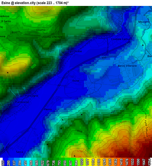
Below is the Elevation map of Esine, which displays elevation range with different colors. Scale of the first map is from 223 to 1704 m (732 to 5591 ft) with average elevation of 599.6 meters (=1967 ft) [note 1]
These maps also provides idea of topography and contour of this city, they are displayed at different zoom levels. More info about maps, scale and edge coordinates you can find below images.
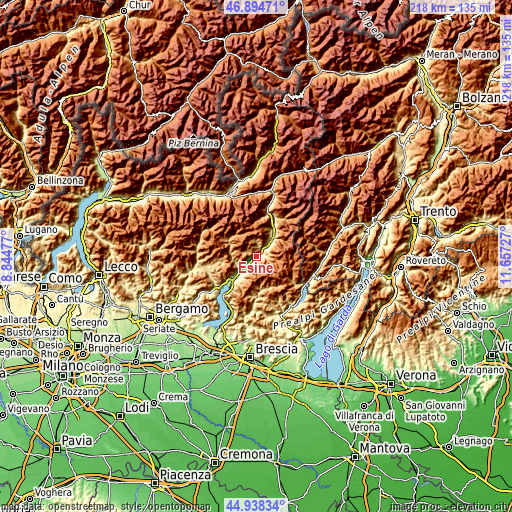
| \ | Map #1 | Topo.Map |
| Scale [m] | 223..1704 m | × |
| Scale [ft] | 732..5591 ft | × |
| Average | 599.6 m = 1967 ft | × |
| Width | 6.8 km = 4.2 mi | 217.5 km = 135.1 mi |
| Height | 6.8 km = 4.2 mi | 217.5 km = 135.1 mi |
| ↑Max Latitude | 45.95571° | 46.89471° |
| Latitude at center | 45.92515° | 45.92515° |
| ↓Min Latitude | 45.894573° | 44.93834° |
| ← Min Longitude | 10.207075° | 8.84477° |
| Longitude center | 10.25102° | 10.25102° |
| →Max Longitude | 10.294965° | 11.65727° |
Nearby cities:
Cities around Esine sort by population:
• Darfo Boario Terme elevation 222 m
6.1 km,  232°
232°
• Piamborno 240 m
2.1 km,  253°
253°
• Breno 312 m
5.7 km,  48°
48°
• Bienno 436 m
3.4 km,  70°
70°
• Cividate Camuno 264 m
2.1 km,  33°
33°
• Borno 911 m
4.5 km,  303°
303°
• Berzo Inferiore 344 m
2.1 km, 74°
• Malegno 302 m
3.4 km, 32°
• Sacca 237 m
3.7 km,  220°
220°
• Ossimo Superiore 874 m
2.8 km,  325°
325°
• Lozio 1003 m
6.8 km,  6°
6°
• Darfo 221 m
7.5 km, 225°
Multilingual:
 En español:
Esine elevación 271 m.
 En France:
Esine élévation 271 m.


Sources and notes:
- [note 1] Map square and city borders are not equal. Map elevation data is calculated only from area inside that square.
- [src 1] Elevation data from geonames database provided with same terms of usage.
- [src 2] The elevation map of Esine is generated using elevation data from NASA's 3 arcsec (90m) resolution SRTM data.
- [src 3] Base (background) map © OpenStreetMap contributors tiles are generated by Geofabrik and OpenTopoMap.
Copyright & License:
This Esine Elevation Map is licensed under CC BY-SA. You may reuse any part from this page, if you give a proper credit by linking to this URL:
 More info on terms of use page.