Fiumalbo-Dogana elevation
Fiumalbo-Dogana (Emilia-Romagna, Provincia di Modena), Italy elevation is 936 meters and Fiumalbo-Dogana elevation in feet is 3071 ft above sea level [src 1]. Fiumalbo-Dogana is a seat of a third-order administrative division (feature code) with elevation that is 614 meters (2014 ft) bigger than average city elevation in Italy.
Below is the Elevation map of Fiumalbo-Dogana, which displays elevation range with different colors. Scale of the first map is from 738 to 1917 m (2421 to 6289 ft) with average elevation of 1231.9 meters (=4042 ft) [note 1]
These maps also provides idea of topography and contour of this city, they are displayed at different zoom levels. More info about maps, scale and edge coordinates you can find below images.
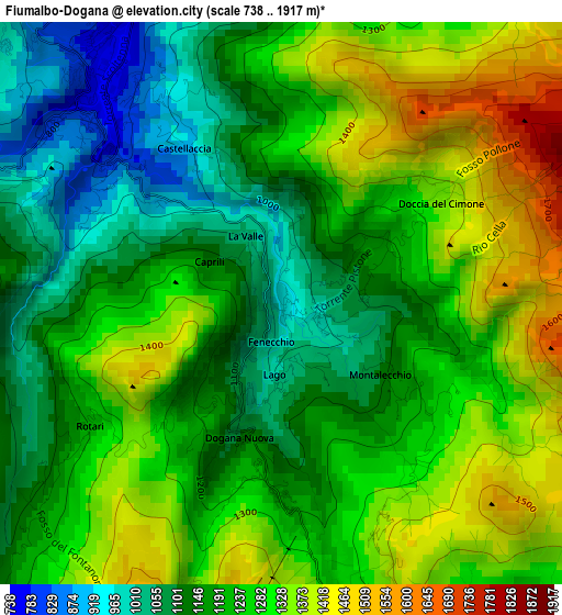
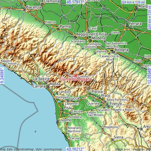
| \ | Map #1 | Topo.Map |
| Scale [m] | 738..1917 m | × |
| Scale [ft] | 2421..6289 ft | × |
| Average | 1231.9 m = 4042 ft | × |
| Width | 7.01 km = 4.4 mi | 224.3 km = 139.4 mi |
| Height | 7.01 km = 4.4 mi | 224.3 km = 139.4 mi |
| ↑Max Latitude | 44.210758° | 45.17913° |
| Latitude at center | 44.17925° | 44.17925° |
| ↓Min Latitude | 44.147726° | 43.16212° |
| ← Min Longitude | 10.603255° | 9.24095° |
| Longitude center | 10.6472° | 10.6472° |
| →Max Longitude | 10.691145° | 12.05345° |
Nearby cities:
Cities around Fiumalbo-Dogana sort by population:
• Fanano elevation 631 m
12.5 km,  72°
72°
• Sestola 993 m
11.5 km,  60°
60°
• Lama 837 m
15.7 km,  25°
25°
• Pievepelago 781 m
3.7 km,  319°
319°
• Coreglia Antelminelli 557 m
16.2 km,  217°
217°
• Palagano 705 m
15.8 km,  359°
359°
• Frassinoro 1111 m
14.2 km,  334°
334°
• Cutigliano 704 m
12.3 km,  135°
135°
• Riolunato 722 m
5.8 km,  4°
4°
• Montecreto 894 m
9.3 km,  37°
37°
• Fosciandora 430 m
16.7 km,  244°
244°
• Abetone 1373 m
3.9 km,  160°
160°
Multilingual:
 En español:
Fiumalbo-Dogana elevación 936 m.
 En France:
Fiumalbo élévation 936 m.
 Auf Deutsch:
Fiumalbo-Dogana höhe über dem Meeresspiegel ist 936 m.

Sources and notes:
- [note 1] Map square and city borders are not equal. Map elevation data is calculated only from area inside that square.
- [src 1] Elevation data from geonames database provided with same terms of usage.
- [src 2] The elevation map of Fiumalbo-Dogana is generated using elevation data from NASA's 3 arcsec (90m) resolution SRTM data.
- [src 3] Base (background) map © OpenStreetMap contributors tiles are generated by Geofabrik and OpenTopoMap.
Copyright & License:
This Fiumalbo-Dogana Elevation Map is licensed under CC BY-SA. You may reuse any part from this page, if you give a proper credit by linking to this URL:
 More info on terms of use page.