Fontanile elevation
Fontanile (Piedmont, Provincia di Asti), Italy elevation is 276 meters and Fontanile elevation in feet is 906 ft above sea level [src 1]. Fontanile is a seat of a third-order administrative division (feature code) with elevation that is 46 meters (151 ft) smaller than average city elevation in Italy.
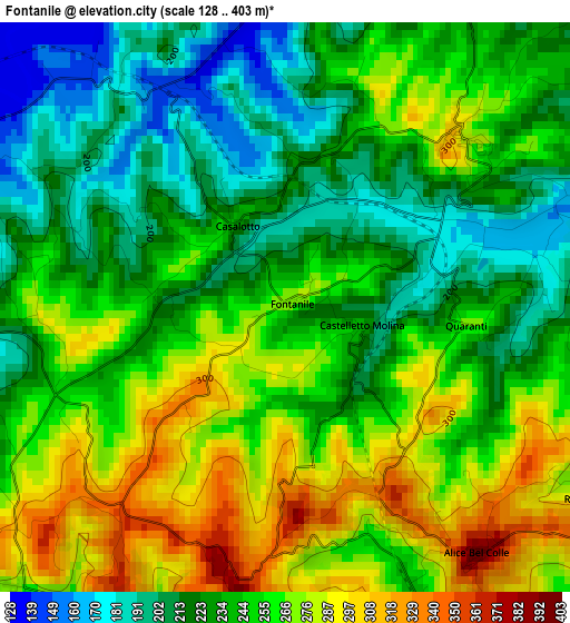
Below is the Elevation map of Fontanile, which displays elevation range with different colors. Scale of the first map is from 128 to 403 m (420 to 1322 ft) with average elevation of 245.6 meters (=806 ft) [note 1]
These maps also provides idea of topography and contour of this city, they are displayed at different zoom levels. More info about maps, scale and edge coordinates you can find below images.
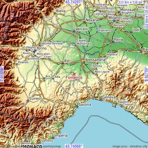
| \ | Map #1 | Topo.Map |
| Scale [m] | 128..403 m | × |
| Scale [ft] | 420..1322 ft | × |
| Average | 245.6 m = 806 ft | × |
| Width | 6.94 km = 4.3 mi | 222.1 km = 138 mi |
| Height | 6.94 km = 4.3 mi | 222.1 km = 138 mi |
| ↑Max Latitude | 44.784149° | 45.74297° |
| Latitude at center | 44.75295° | 44.75295° |
| ↓Min Latitude | 44.721734° | 43.74568° |
| ← Min Longitude | 8.377395° | 7.01509° |
| Longitude center | 8.42134° | 8.42134° |
| →Max Longitude | 8.465285° | 9.82759° |
Nearby cities:
Cities around Fontanile sort by population:
• Nizza Monferrato elevation 144 m
5.5 km,  295°
295°
• Castelnuovo Belbo 125 m
5.4 km,  352°
352°
• Mombaruzzo 286 m
3 km,  45°
45°
• Ricaldone 292 m
4.3 km,  121°
121°
• Bruno 145 m
4.6 km,  18°
18°
• Alice Bel Colle 403 m
3.8 km,  142°
142°
• Castel Rocchero 414 m
3.9 km,  187°
187°
• Maranzana 266 m
4.6 km,  79°
79°
• Castel Boglione 267 m
4.8 km,  223°
223°
• Quaranti 268 m
2.2 km,  95°
95°
• Castelletto Molina 233 m
1 km, 101°
• Montabone 449 m
6.5 km,  201°
201°
Multilingual:
 En español:
Fontanile elevación 276 m.
 En France:
Fontanile élévation 276 m.
 Auf Deutsch:
Fontanile höhe über dem Meeresspiegel ist 276 m.

Sources and notes:
- [note 1] Map square and city borders are not equal. Map elevation data is calculated only from area inside that square.
- [src 1] Elevation data from geonames database provided with same terms of usage.
- [src 2] The elevation map of Fontanile is generated using elevation data from NASA's 3 arcsec (90m) resolution SRTM data.
- [src 3] Base (background) map © OpenStreetMap contributors tiles are generated by Geofabrik and OpenTopoMap.
Copyright & License:
This Fontanile Elevation Map is licensed under CC BY-SA. You may reuse any part from this page, if you give a proper credit by linking to this URL:
 More info on terms of use page.