Fonteblanda elevation
Fonteblanda (Tuscany, Provincia di Grosseto), Italy elevation is 33 meters and Fonteblanda elevation in feet is 108 ft above sea level [src 1]. Fonteblanda is a populated place (feature code) with elevation that is 289 meters (948 ft) smaller than average city elevation in Italy.
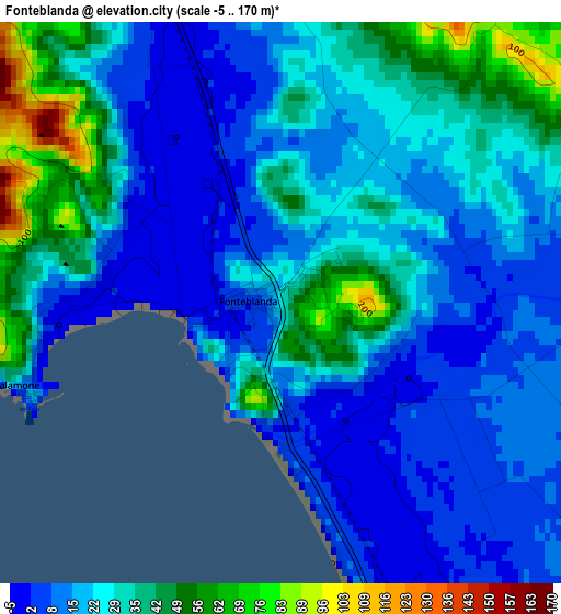
Below is the Elevation map of Fonteblanda, which displays elevation range with different colors. Scale of the first map is from -5 to 170 m (-16 to 558 ft) with average elevation of 24.3 meters (=80 ft) [note 1]
These maps also provides idea of topography and contour of this city, they are displayed at different zoom levels. More info about maps, scale and edge coordinates you can find below images.
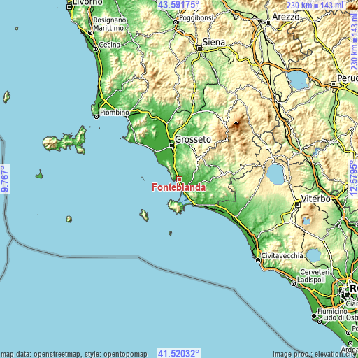
| \ | Map #1 | Topo.Map |
| Scale [m] | -5..170 m | × |
| Scale [ft] | -16..558 ft | × |
| Average | 24.3 m = 80 ft | × |
| Width | 7.2 km = 4.5 mi | 230.3 km = 143.1 mi |
| Height | 7.2 km = 4.5 mi | 230.3 km = 143.1 mi |
| ↑Max Latitude | 42.596988° | 43.59175° |
| Latitude at center | 42.56463° | 42.56463° |
| ↓Min Latitude | 42.532255° | 41.52032° |
| ← Min Longitude | 11.129305° | 9.767° |
| Longitude center | 11.17325° | 11.17325° |
| →Max Longitude | 11.217195° | 12.5795° |
Nearby cities:
Cities around Fonteblanda sort by population:
• Grosseto elevation 15 m
22.7 km,  346°
346°
• Monte Argentario 28 m
15.1 km,  196°
196°
• Porto Santo Stefano 28 m
14.8 km, 198°
• Orbetello 1 m
14.2 km,  163°
163°
• Albinia 6 m
7.5 km, 156°
• Porto Ercole 3 m
18.3 km,  171°
171°
• Marina di Grosseto 5 m
23.3 km,  317°
317°
• Orbetello Scalo 6 m
14.3 km,  154°
154°
• Istia D'Ombrone-Le Stiacciole 36 m
24.2 km,  2°
2°
• Scansano 548 m
18.7 km,  43°
43°
• Magliano in Toscana 123 m
10.4 km,  69°
69°
• Capalbio 168 m
23.8 km,  121°
121°
Multilingual:
 En español:
Fonteblanda elevación 33 m.
 En France:
Fonteblanda élévation 33 m.
 Auf Deutsch:
Fonteblanda höhe über dem Meeresspiegel ist 33 m.

Sources and notes:
- [note 1] Map square and city borders are not equal. Map elevation data is calculated only from area inside that square.
- [src 1] Elevation data from geonames database provided with same terms of usage.
- [src 2] The elevation map of Fonteblanda is generated using elevation data from NASA's 3 arcsec (90m) resolution SRTM data.
- [src 3] Base (background) map © OpenStreetMap contributors tiles are generated by Geofabrik and OpenTopoMap.
Copyright & License:
This Fonteblanda Elevation Map is licensed under CC BY-SA. You may reuse any part from this page, if you give a proper credit by linking to this URL:
 More info on terms of use page.