Fortezza elevation
Fortezza (Trentino-Alto Adige, Bolzano), Italy elevation is 745 meters and Fortezza elevation in feet is 2444 ft above sea level [src 1]. Fortezza is a seat of a third-order administrative division (feature code) with elevation that is 423 meters (1388 ft) bigger than average city elevation in Italy.
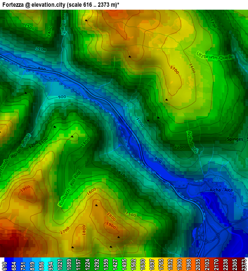
Below is the Elevation map of Fortezza, which displays elevation range with different colors. Scale of the first map is from 616 to 2373 m (2021 to 7785 ft) with average elevation of 1313.8 meters (=4310 ft) [note 1]
These maps also provides idea of topography and contour of this city, they are displayed at different zoom levels. More info about maps, scale and edge coordinates you can find below images.
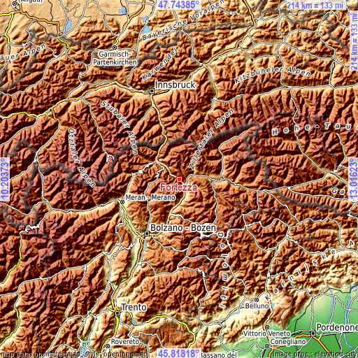
| \ | Map #1 | Topo.Map |
| Scale [m] | 616..2373 m | × |
| Scale [ft] | 2021..7785 ft | × |
| Average | 1313.8 m = 4310 ft | × |
| Width | 6.69 km = 4.2 mi | 214.1 km = 133 mi |
| Height | 6.69 km = 4.2 mi | 214.1 km = 133 mi |
| ↑Max Latitude | 46.81971° | 47.74385° |
| Latitude at center | 46.78963° | 46.78963° |
| ↓Min Latitude | 46.759533° | 45.81818° |
| ← Min Longitude | 11.566035° | 10.20373° |
| Longitude center | 11.60998° | 11.60998° |
| →Max Longitude | 11.653925° | 13.01623° |
Nearby cities:
Cities around Fortezza sort by population:
• Bressanone elevation 563 m
9 km,  157°
157°
• Vandoies - Vintl 758 m
8.9 km,  71°
71°
• Naz-Sciaves - Natz-Schabs 777 m
4.8 km,  118°
118°
• Varna 642 m
6 km, 159°
• Luson - Luesen 971 m
12.5 km,  112°
112°
• Rodengo 1351 m
6.9 km,  80°
80°
• Rodengo - Rodeneck 899 m
6.2 km,  100°
100°
• Rio di Pusteria 770 m
4.4 km, 79°
• Leone-Santa Elisabetta 575 m
7.1 km,  154°
154°
• Vandoies di Sotto 761 m
9 km, 70°
• Villa 904 m
6.2 km, 100°
• Sciaves 787 m
4.9 km, 118°
Multilingual:
 En español:
Fortezza elevación 745 m.
 En France:
Fortezza élévation 745 m.
 Auf Deutsch:
Fortezza höhe über dem Meeresspiegel ist 745 m.

Sources and notes:
- [note 1] Map square and city borders are not equal. Map elevation data is calculated only from area inside that square.
- [src 1] Elevation data from geonames database provided with same terms of usage.
- [src 2] The elevation map of Fortezza is generated using elevation data from NASA's 3 arcsec (90m) resolution SRTM data.
- [src 3] Base (background) map © OpenStreetMap contributors tiles are generated by Geofabrik and OpenTopoMap.
Copyright & License:
This Fortezza Elevation Map is licensed under CC BY-SA. You may reuse any part from this page, if you give a proper credit by linking to this URL:
 More info on terms of use page.