Galeata elevation
Galeata (Emilia-Romagna, Provincia di Forlì-Cesena), Italy elevation is 235 meters and Galeata elevation in feet is 771 ft above sea level [src 1]. Galeata is a seat of a third-order administrative division (feature code) with elevation that is 87 meters (285 ft) smaller than average city elevation in Italy.
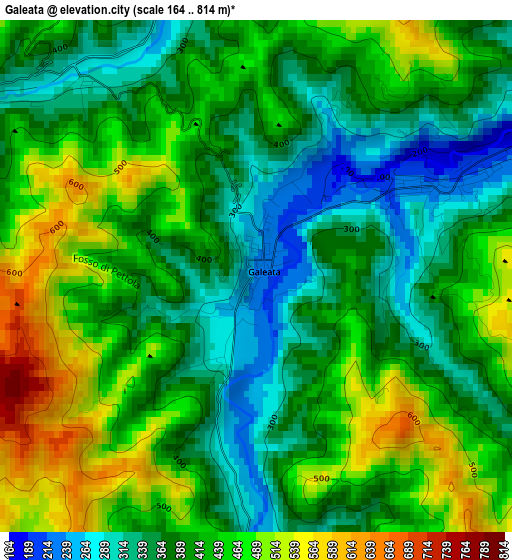
Below is the Elevation map of Galeata, which displays elevation range with different colors. Scale of the first map is from 164 to 814 m (538 to 2671 ft) with average elevation of 410.2 meters (=1346 ft) [note 1]
These maps also provides idea of topography and contour of this city, they are displayed at different zoom levels. More info about maps, scale and edge coordinates you can find below images.
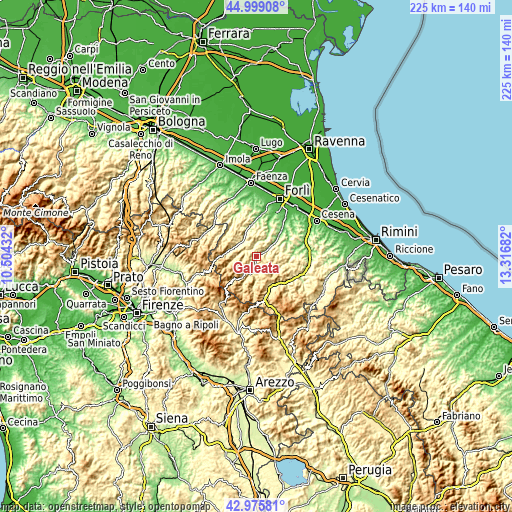
| \ | Map #1 | Topo.Map |
| Scale [m] | 164..814 m | × |
| Scale [ft] | 538..2671 ft | × |
| Average | 410.2 m = 1346 ft | × |
| Width | 7.03 km = 4.4 mi | 225 km = 139.8 mi |
| Height | 7.03 km = 4.4 mi | 225 km = 139.8 mi |
| ↑Max Latitude | 44.027675° | 44.99908° |
| Latitude at center | 43.99607° | 43.99607° |
| ↓Min Latitude | 43.964448° | 42.97581° |
| ← Min Longitude | 11.866625° | 10.50432° |
| Longitude center | 11.91057° | 11.91057° |
| →Max Longitude | 11.954515° | 13.31682° |
Nearby cities:
Cities around Galeata sort by population:
• San Piero in Bagno elevation 466 m
16.3 km,  160°
160°
• Santa Sofia 257 m
5.4 km,  181°
181°
• Predappio 125 m
13.3 km,  26°
26°
• Fiumana 75 m
17.5 km,  20°
20°
• Rocca San Casciano 213 m
8.8 km,  322°
322°
• Civitella di Romagna 208 m
3 km,  63°
63°
• Dovadola 132 m
14.1 km,  352°
352°
• Cusercoli 115 m
9.5 km,  54°
54°
• Tredozio 346 m
16.4 km,  304°
304°
• Portico e San Benedetto 316 m
10.9 km,  288°
288°
• Premilcuore 476 m
10.4 km,  260°
260°
• Portico di Romagna 316 m
10.9 km, 288°
Multilingual:
 En español:
Galeata elevación 235 m.
 En France:
Galeata élévation 235 m.


Sources and notes:
- [note 1] Map square and city borders are not equal. Map elevation data is calculated only from area inside that square.
- [src 1] Elevation data from geonames database provided with same terms of usage.
- [src 2] The elevation map of Galeata is generated using elevation data from NASA's 3 arcsec (90m) resolution SRTM data.
- [src 3] Base (background) map © OpenStreetMap contributors tiles are generated by Geofabrik and OpenTopoMap.
Copyright & License:
This Galeata Elevation Map is licensed under CC BY-SA. You may reuse any part from this page, if you give a proper credit by linking to this URL:
 More info on terms of use page.