Gambara elevation
Gambara (Lombardy, Provincia di Brescia), Italy elevation is 48 meters and Gambara elevation in feet is 157 ft above sea level [src 1]. Gambara is a seat of a third-order administrative division (feature code) with elevation that is 274 meters (899 ft) smaller than average city elevation in Italy.
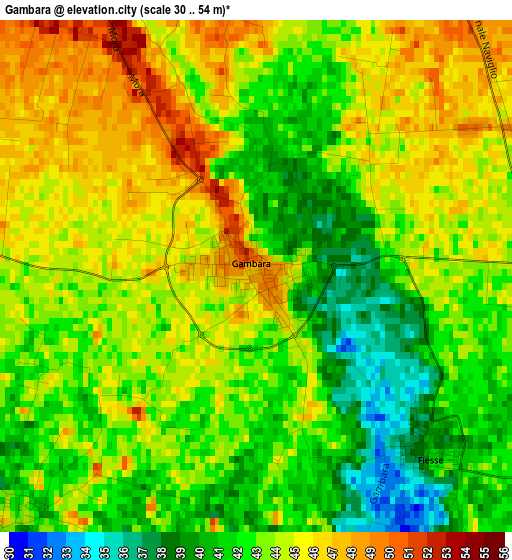
Below is the Elevation map of Gambara, which displays elevation range with different colors. Scale of the first map is from 30 to 54 m (98 to 177 ft) with average elevation of 43.1 meters (=141 ft) [note 1]
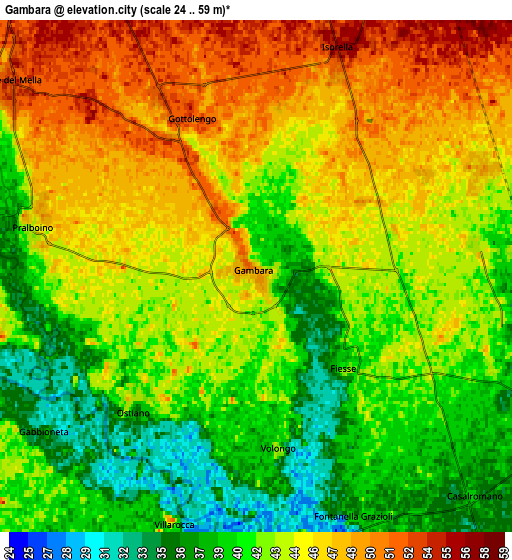
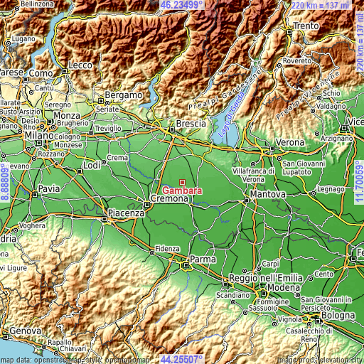
These maps also provides idea of topography and contour of this city, they are displayed at different zoom levels. More info about maps, scale and edge coordinates you can find below images.
| \ | Map #1 | Map #2 | Topo.Map |
| Scale [m] | 30..54 m | 24..59 m | × |
| Scale [ft] | 98..177 ft | 79..194 ft | × |
| Average | 43.1 m = 141 ft | 43.1 m = 141 ft | × |
| Width | 6.88 km = 4.3 mi | 13.76 km = 8.6 mi | 220.1 km = 136.8 mi |
| Height | 6.88 km = 4.3 mi | 13.76 km = 8.6 mi | 220.1 km = 136.8 mi |
| ↑Max Latitude | 45.284588° | 45.315499° | 46.23499° |
| Latitude at center | 45.25366° | 45.25366° | 45.25366° |
| ↓Min Latitude | 45.222715° | 45.191754° | 44.25507° |
| ← Min Longitude | 10.250395° | 10.206449° | 8.88809° |
| Longitude center | 10.29434° | 10.29434° | 10.29434° |
| →Max Longitude | 10.338285° | 10.382231° | 11.70059° |
Nearby cities:
Cities around Gambara sort by population:
• Gottolengo elevation 51 m
4.8 km,  335°
335°
• Isorella 55 m
6.6 km,  19°
19°
• Remedello 49 m
6.7 km,  65°
65°
• Ostiano 37 m
4.7 km,  222°
222°
• Pralboino 44 m
6.1 km,  284°
284°
• Remedello di Sopra 47 m
6.6 km, 65°
• Milzano 45 m
7.8 km,  286°
286°
• Fiesse 41 m
3.3 km,  135°
135°
• Casalromano 37 m
8.4 km, 137°
• Volongo 44 m
4.7 km,  172°
172°
• Gabbioneta 36 m
7.1 km,  234°
234°
• Pessina Cremonese 40 m
8.4 km,  205°
205°
Multilingual:
 En español:
Gambara elevación 48 m.
 En France:
Gambara élévation 48 m.


Sources and notes:
- [note 1] Map square and city borders are not equal. Map elevation data is calculated only from area inside that square.
- [src 1] Elevation data from geonames database provided with same terms of usage.
- [src 2] The elevation map of Gambara is generated using elevation data from NASA's 3 arcsec (90m) resolution SRTM data.
- [src 3] Base (background) map © OpenStreetMap contributors tiles are generated by Geofabrik and OpenTopoMap.
Copyright & License:
This Gambara Elevation Map is licensed under CC BY-SA. You may reuse any part from this page, if you give a proper credit by linking to this URL:
 More info on terms of use page.