Gazzuolo elevation
Gazzuolo (Lombardy, Provincia di Mantova), Italy elevation is 23 meters and Gazzuolo elevation in feet is 75 ft above sea level [src 1]. Gazzuolo is a seat of a third-order administrative division (feature code) with elevation that is 299 meters (981 ft) smaller than average city elevation in Italy.
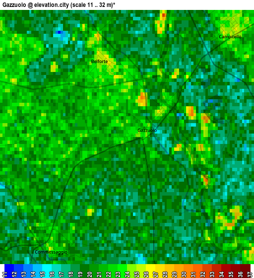
Below is the Elevation map of Gazzuolo, which displays elevation range with different colors. Scale of the first map is from 11 to 32 m (36 to 105 ft) with average elevation of 19.8 meters (=65 ft) [note 1]
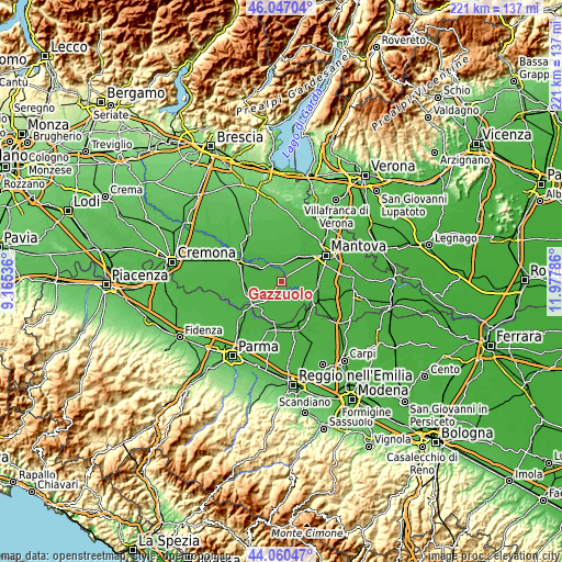
These maps also provides idea of topography and contour of this city, they are displayed at different zoom levels. More info about maps, scale and edge coordinates you can find below images.
| \ | Map #1 | Topo.Map |
| Scale [m] | 11..32 m | × |
| Scale [ft] | 36..105 ft | × |
| Average | 19.8 m = 65 ft | × |
| Width | 6.9 km = 4.3 mi | 220.9 km = 137.3 mi |
| Height | 6.9 km = 4.3 mi | 220.9 km = 137.3 mi |
| ↑Max Latitude | 45.093412° | 46.04704° |
| Latitude at center | 45.06238° | 45.06238° |
| ↓Min Latitude | 45.031331° | 44.06047° |
| ← Min Longitude | 10.527665° | 9.16536° |
| Longitude center | 10.57161° | 10.57161° |
| →Max Longitude | 10.615555° | 11.97786° |
Nearby cities:
Cities around Gazzuolo sort by population:
• Bozzolo elevation 28 m
8.5 km,  302°
302°
• Castellucchio 26 m
11.5 km,  31°
31°
• Rivarolo Mantovano 26 m
10.6 km,  276°
276°
• Campitello 25 m
3.9 km,  44°
44°
• Buscoldo 22 m
10.4 km,  70°
70°
• Sabbioneta 24 m
9.7 km,  222°
222°
• San Martino Dall'Argine 28 m
5.7 km,  312°
312°
• Rivarolo del Re 24 m
8.5 km,  245°
245°
• Belforte 25 m
2.2 km,  339°
339°
• Commessaggio 24 m
3.4 km, 216°
• Marcaria 27 m
7.3 km, 335°
• Spineda 24 m
4.7 km,  268°
268°
Multilingual:
 En español:
Gazzuolo elevación 23 m.
 En France:
Gazzuolo élévation 23 m.


Sources and notes:
- [note 1] Map square and city borders are not equal. Map elevation data is calculated only from area inside that square.
- [src 1] Elevation data from geonames database provided with same terms of usage.
- [src 2] The elevation map of Gazzuolo is generated using elevation data from NASA's 3 arcsec (90m) resolution SRTM data.
- [src 3] Base (background) map © OpenStreetMap contributors tiles are generated by Geofabrik and OpenTopoMap.
Copyright & License:
This Gazzuolo Elevation Map is licensed under CC BY-SA. You may reuse any part from this page, if you give a proper credit by linking to this URL:
 More info on terms of use page.