Gessopalena elevation
Gessopalena (Abruzzo, Provincia di Chieti), Italy elevation is 648 meters and Gessopalena elevation in feet is 2126 ft above sea level [src 1]. Gessopalena is a seat of a third-order administrative division (feature code) with elevation that is 326 meters (1070 ft) bigger than average city elevation in Italy.
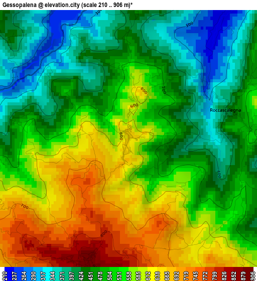
Below is the Elevation map of Gessopalena, which displays elevation range with different colors. Scale of the first map is from 210 to 906 m (689 to 2972 ft) with average elevation of 517.7 meters (=1698 ft) [note 1]
These maps also provides idea of topography and contour of this city, they are displayed at different zoom levels. More info about maps, scale and edge coordinates you can find below images.
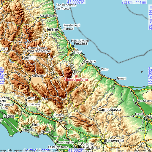
| \ | Map #1 | Topo.Map |
| Scale [m] | 210..906 m | × |
| Scale [ft] | 689..2972 ft | × |
| Average | 517.7 m = 1698 ft | × |
| Width | 7.26 km = 4.5 mi | 232.2 km = 144.3 mi |
| Height | 7.26 km = 4.5 mi | 232.2 km = 144.3 mi |
| ↑Max Latitude | 42.087831° | 43.09076° |
| Latitude at center | 42.05521° | 42.05521° |
| ↓Min Latitude | 42.022572° | 41.0025° |
| ← Min Longitude | 14.229725° | 12.86742° |
| Longitude center | 14.27367° | 14.27367° |
| →Max Longitude | 14.317615° | 15.67992° |
Nearby cities:
Cities around Gessopalena sort by population:
• Casoli elevation 348 m
6.7 km,  11°
11°
• Fara San Martino 422 m
6.8 km,  307°
307°
• Lama dei Peligni 674 m
7.3 km,  258°
258°
• Torricella Peligna 885 m
3.7 km,  199°
199°
• Bomba 419 m
8 km,  107°
107°
• Palombaro 521 m
8.4 km,  334°
334°
• Altino 346 m
6.9 km,  44°
44°
• Roccascalegna 437 m
2.9 km,  74°
74°
• Pennadomo 448 m
7 km,  144°
144°
• Civitella Messer Raimondo 597 m
6 km, 308°
• Colledimacine 786 m
8.3 km,  226°
226°
• Montebello sul Sangro 745 m
8.7 km,  151°
151°
Multilingual:
 En español:
Gessopalena elevación 648 m.
 En France:
Gessopalena élévation 648 m.
 Auf Deutsch:
Gessopalena höhe über dem Meeresspiegel ist 648 m.

Sources and notes:
- [note 1] Map square and city borders are not equal. Map elevation data is calculated only from area inside that square.
- [src 1] Elevation data from geonames database provided with same terms of usage.
- [src 2] The elevation map of Gessopalena is generated using elevation data from NASA's 3 arcsec (90m) resolution SRTM data.
- [src 3] Base (background) map © OpenStreetMap contributors tiles are generated by Geofabrik and OpenTopoMap.
Copyright & License:
This Gessopalena Elevation Map is licensed under CC BY-SA. You may reuse any part from this page, if you give a proper credit by linking to this URL:
 More info on terms of use page.