Isola Sant'Antonio elevation
Isola Sant'Antonio (Piedmont, Provincia di Alessandria), Italy elevation is 75 meters and Isola Sant'Antonio elevation in feet is 246 ft above sea level [src 1]. Isola Sant'Antonio is a seat of a third-order administrative division (feature code) with elevation that is 247 meters (810 ft) smaller than average city elevation in Italy.
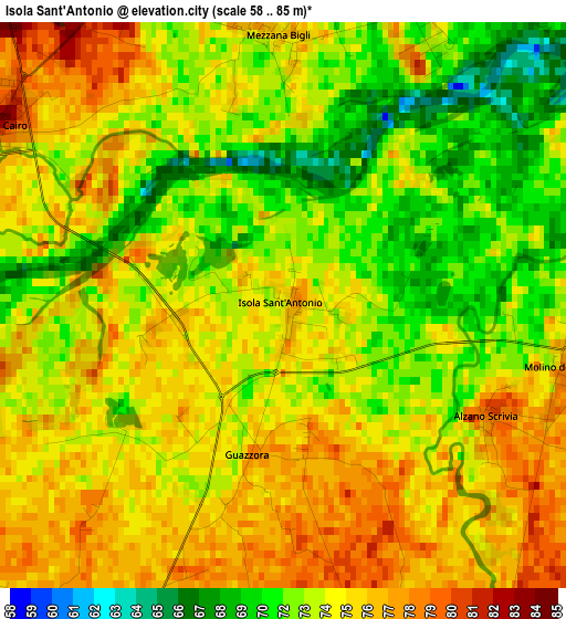
Below is the Elevation map of Isola Sant'Antonio, which displays elevation range with different colors. Scale of the first map is from 58 to 85 m (190 to 279 ft) with average elevation of 73.7 meters (=242 ft) [note 1]
These maps also provides idea of topography and contour of this city, they are displayed at different zoom levels. More info about maps, scale and edge coordinates you can find below images.
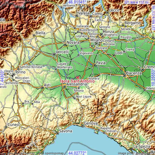
| \ | Map #1 | Topo.Map |
| Scale [m] | 58..85 m | × |
| Scale [ft] | 190..279 ft | × |
| Average | 73.7 m = 242 ft | × |
| Width | 6.91 km = 4.3 mi | 221 km = 137.3 mi |
| Height | 6.91 km = 4.3 mi | 221 km = 137.3 mi |
| ↑Max Latitude | 45.061239° | 46.01541° |
| Latitude at center | 45.03019° | 45.03019° |
| ↓Min Latitude | 44.999124° | 44.02772° |
| ← Min Longitude | 8.805335° | 7.44303° |
| Longitude center | 8.84928° | 8.84928° |
| →Max Longitude | 8.893225° | 10.25553° |
Nearby cities:
Cities around Isola Sant'Antonio sort by population:
• Castelnuovo Scrivia elevation 88 m
6.2 km,  155°
155°
• Sale 83 m
6.5 km,  208°
208°
• Casei 83 m
6.6 km,  112°
112°
• Pieve del Cairo 81 m
4.2 km,  300°
300°
• Cornale 76 m
5.1 km,  73°
73°
• Molino dei Torti 77 m
3.5 km,  100°
100°
• Mezzana Bigli 75 m
3.3 km,  357°
357°
• Alzano Scrivia 80 m
2.8 km,  118°
118°
• Guazzora 75 m
1.8 km,  182°
182°
• Bastida de' Dossi 78 m
5.8 km,  79°
79°
• Gambarana 84 m
6.8 km,  268°
268°
• Montariolo 80 m
7 km,  236°
236°
Multilingual:
 En español:
Isola Sant'Antonio elevación 75 m.
 En France:
Isola Sant'Antonio élévation 75 m.
 Auf Deutsch:
Isola Sant'Antonio höhe über dem Meeresspiegel ist 75 m.

Sources and notes:
- [note 1] Map square and city borders are not equal. Map elevation data is calculated only from area inside that square.
- [src 1] Elevation data from geonames database provided with same terms of usage.
- [src 2] The elevation map of Isola Sant'Antonio is generated using elevation data from NASA's 3 arcsec (90m) resolution SRTM data.
- [src 3] Base (background) map © OpenStreetMap contributors tiles are generated by Geofabrik and OpenTopoMap.
Copyright & License:
This Isola Sant'Antonio Elevation Map is licensed under CC BY-SA. You may reuse any part from this page, if you give a proper credit by linking to this URL:
 More info on terms of use page.