Istrana elevation
Istrana (Veneto, Provincia di Treviso), Italy elevation is 35 meters and Istrana elevation in feet is 115 ft above sea level [src 1]. Istrana is a seat of a third-order administrative division (feature code) with elevation that is 287 meters (942 ft) smaller than average city elevation in Italy.
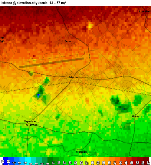
Below is the Elevation map of Istrana, which displays elevation range with different colors. Scale of the first map is from -13 to 57 m (-43 to 187 ft) with average elevation of 33.9 meters (=111 ft) [note 1]
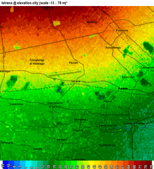
These maps also provides idea of topography and contour of this city, they are displayed at different zoom levels. More info about maps, scale and edge coordinates you can find below images.
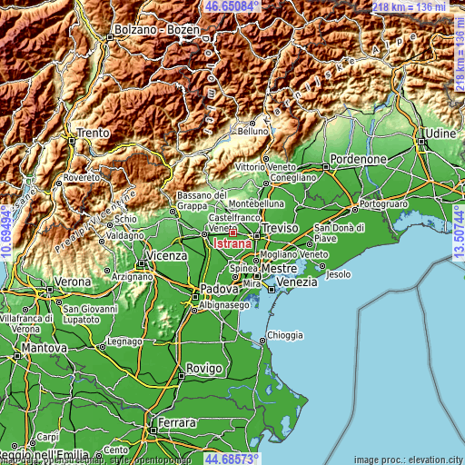
| \ | Map #1 | Map #2 | Topo.Map |
| Scale [m] | -13..57 m | -13..78 m | × |
| Scale [ft] | -43..187 ft | -43..256 ft | × |
| Average | 33.9 m = 111 ft | 35.9 m = 118 ft | × |
| Width | 6.83 km = 4.2 mi | 13.66 km = 8.5 mi | 218.5 km = 135.8 mi |
| Height | 6.83 km = 4.2 mi | 13.66 km = 8.5 mi | 218.5 km = 135.8 mi |
| ↑Max Latitude | 45.707606° | 45.738286° | 46.65084° |
| Latitude at center | 45.67691° | 45.67691° | 45.67691° |
| ↓Min Latitude | 45.646197° | 45.615467° | 44.68573° |
| ← Min Longitude | 12.057245° | 12.013299° | 10.69494° |
| Longitude center | 12.10119° | 12.10119° | 12.10119° |
| →Max Longitude | 12.145135° | 12.189081° | 13.50744° |
Nearby cities:
Cities around Istrana sort by population:
• Paese elevation 29 m
4.9 km,  93°
93°
• Quinto di Treviso 15 m
6.2 km,  126°
126°
• Postioma 52 m
6 km,  41°
41°
• Padernello 37 m
2.1 km,  75°
75°
• Ospedaletto 28 m
2.4 km,  226°
226°
• Badoere 22 m
4.9 km,  194°
194°
• Musano 69 m
5.7 km,  13°
13°
• Fossalunga 42 m
4.1 km,  293°
293°
• Porcellengo 48 m
4.6 km, 44°
• Santa Cristina 17 m
4.7 km,  141°
141°
• Casacorba 26 m
5.2 km,  248°
248°
• Pezzan 45 m
1.9 km,  347°
347°
Multilingual:
 En español:
Istrana elevación 35 m.
 En France:
Istrana élévation 35 m.


Sources and notes:
- [note 1] Map square and city borders are not equal. Map elevation data is calculated only from area inside that square.
- [src 1] Elevation data from geonames database provided with same terms of usage.
- [src 2] The elevation map of Istrana is generated using elevation data from NASA's 3 arcsec (90m) resolution SRTM data.
- [src 3] Base (background) map © OpenStreetMap contributors tiles are generated by Geofabrik and OpenTopoMap.
Copyright & License:
This Istrana Elevation Map is licensed under CC BY-SA. You may reuse any part from this page, if you give a proper credit by linking to this URL:
 More info on terms of use page.