Laglio elevation
Laglio (Lombardy, Provincia di Como), Italy elevation is 250 meters and Laglio elevation in feet is 820 ft above sea level [src 1]. Laglio is a seat of a third-order administrative division (feature code) with elevation that is 72 meters (236 ft) smaller than average city elevation in Italy.
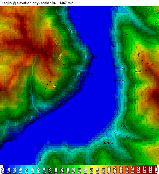
Below is the Elevation map of Laglio, which displays elevation range with different colors. Scale of the first map is from 194 to 1367 m (636 to 4485 ft) with average elevation of 581.6 meters (=1908 ft) [note 1]
These maps also provides idea of topography and contour of this city, they are displayed at different zoom levels. More info about maps, scale and edge coordinates you can find below images.
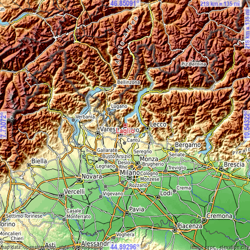
| \ | Map #1 | Topo.Map |
| Scale [m] | 194..1367 m | × |
| Scale [ft] | 636..4485 ft | × |
| Average | 581.6 m = 1908 ft | × |
| Width | 6.8 km = 4.2 mi | 217.7 km = 135.3 mi |
| Height | 6.8 km = 4.2 mi | 217.7 km = 135.3 mi |
| ↑Max Latitude | 45.911144° | 46.85091° |
| Latitude at center | 45.88056° | 45.88056° |
| ↓Min Latitude | 45.849959° | 44.89296° |
| ← Min Longitude | 9.093025° | 7.73072° |
| Longitude center | 9.13697° | 9.13697° |
| →Max Longitude | 9.180915° | 10.54322° |
Nearby cities:
Cities around Laglio sort by population:
• Moltrasio elevation 231 m
3.8 km,  232°
232°
• Carate Urio 256 m
1.5 km, 229°
• Torno 273 m
3.1 km,  209°
209°
• Blevio 264 m
4.9 km, 210°
• Faggeto Lario 532 m
3 km,  144°
144°
• Nesso 319 m
3.9 km,  23°
23°
• Occagno 558 m
6.1 km,  331°
331°
• Pognana Lario 254 m
1.6 km,  90°
90°
• Brienno 213 m
3.5 km,  352°
352°
• Lemna 548 m
3.1 km, 144°
• Veleso 845 m
4.6 km,  47°
47°
• Zelbio 789 m
4.3 km, 51°
Multilingual:
 En español:
Laglio elevación 250 m.
 En France:
Laglio élévation 250 m.


Sources and notes:
- [note 1] Map square and city borders are not equal. Map elevation data is calculated only from area inside that square.
- [src 1] Elevation data from geonames database provided with same terms of usage.
- [src 2] The elevation map of Laglio is generated using elevation data from NASA's 3 arcsec (90m) resolution SRTM data.
- [src 3] Base (background) map © OpenStreetMap contributors tiles are generated by Geofabrik and OpenTopoMap.
Copyright & License:
This Laglio Elevation Map is licensed under CC BY-SA. You may reuse any part from this page, if you give a proper credit by linking to this URL:
 More info on terms of use page.