Lamon elevation
Lamon (Veneto, Provincia di Belluno), Italy elevation is 594 meters and Lamon elevation in feet is 1949 ft above sea level [src 1]. Lamon is a seat of a third-order administrative division (feature code) with elevation that is 272 meters (892 ft) bigger than average city elevation in Italy.
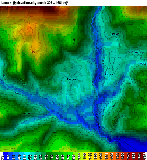
Below is the Elevation map of Lamon, which displays elevation range with different colors. Scale of the first map is from 308 to 1681 m (1010 to 5515 ft) with average elevation of 747.5 meters (=2452 ft) [note 1]
These maps also provides idea of topography and contour of this city, they are displayed at different zoom levels. More info about maps, scale and edge coordinates you can find below images.
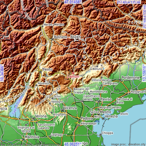
| \ | Map #1 | Topo.Map |
| Scale [m] | 308..1681 m | × |
| Scale [ft] | 1010..5515 ft | × |
| Average | 747.5 m = 2452 ft | × |
| Width | 6.78 km = 4.2 mi | 217 km = 134.8 mi |
| Height | 6.78 km = 4.2 mi | 217 km = 134.8 mi |
| ↑Max Latitude | 46.077663° | 47.01458° |
| Latitude at center | 46.04717° | 46.04717° |
| ↓Min Latitude | 46.016661° | 45.06251° |
| ← Min Longitude | 11.705965° | 10.34366° |
| Longitude center | 11.74991° | 11.74991° |
| →Max Longitude | 11.793855° | 13.15616° |
Nearby cities:
Cities around Lamon sort by population:
• Feltre elevation 275 m
12 km,  104°
104°
• Pedavena 337 m
10.3 km,  94°
94°
• Fonzaso 322 m
5.1 km,  132°
132°
• Sovramonte 618 m
3.1 km,  65°
65°
• Seren del Grappa 316 m
10 km,  124°
124°
• Imer 649 m
11.8 km,  14°
14°
• Castello Tesino 837 m
9.2 km,  281°
281°
• Arsiè 312 m
7.3 km,  175°
175°
• Grigno 265 m
9.5 km,  248°
248°
• Pieve Tesino 834 m
11 km, 282°
• Cinte Tesino 855 m
10.5 km, 276°
• Servo 618 m
3.1 km, 66°
Multilingual:
 En español:
Lamon elevación 594 m.
 En France:
Lamon élévation 594 m.


Sources and notes:
- [note 1] Map square and city borders are not equal. Map elevation data is calculated only from area inside that square.
- [src 1] Elevation data from geonames database provided with same terms of usage.
- [src 2] The elevation map of Lamon is generated using elevation data from NASA's 3 arcsec (90m) resolution SRTM data.
- [src 3] Base (background) map © OpenStreetMap contributors tiles are generated by Geofabrik and OpenTopoMap.
Copyright & License:
This Lamon Elevation Map is licensed under CC BY-SA. You may reuse any part from this page, if you give a proper credit by linking to this URL:
 More info on terms of use page.