Lapio elevation
Lapio (Campania, Provincia di Avellino), Italy elevation is 486 meters and Lapio elevation in feet is 1594 ft above sea level [src 1]. Lapio is a seat of a third-order administrative division (feature code) with elevation that is 164 meters (538 ft) bigger than average city elevation in Italy.
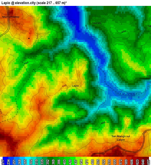
Below is the Elevation map of Lapio, which displays elevation range with different colors. Scale of the first map is from 217 to 657 m (712 to 2156 ft) with average elevation of 421.8 meters (=1384 ft) [note 1]
These maps also provides idea of topography and contour of this city, they are displayed at different zoom levels. More info about maps, scale and edge coordinates you can find below images.
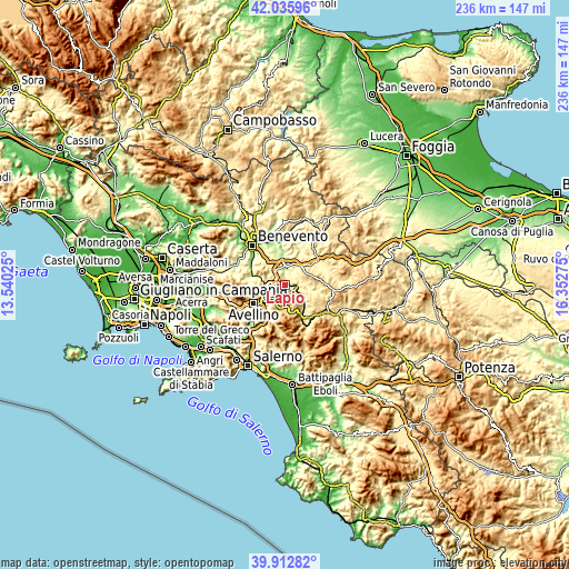
| \ | Map #1 | Topo.Map |
| Scale [m] | 217..657 m | × |
| Scale [ft] | 712..2156 ft | × |
| Average | 421.8 m = 1384 ft | × |
| Width | 7.38 km = 4.6 mi | 236.1 km = 146.7 mi |
| Height | 7.38 km = 4.6 mi | 236.1 km = 146.7 mi |
| ↑Max Latitude | 41.016096° | 42.03596° |
| Latitude at center | 40.98293° | 40.98293° |
| ↓Min Latitude | 40.949747° | 39.91282° |
| ← Min Longitude | 14.902555° | 13.54025° |
| Longitude center | 14.9465° | 14.9465° |
| →Max Longitude | 14.990445° | 16.35275° |
Nearby cities:
Cities around Lapio sort by population:
• Montemiletto elevation 570 m
5 km,  309°
309°
• Fontanarosa 508 m
7.3 km,  57°
57°
• Taurasi 369 m
3.3 km,  19°
19°
• Montefalcione 541 m
5.8 km,  246°
246°
• Paternopoli 496 m
7.3 km,  98°
98°
• Castelvetere sul Calore 760 m
6.8 km,  150°
150°
• Campanarello 362 m
7.6 km,  339°
339°
• Chiusano di San Domenico 704 m
6.1 km,  204°
204°
• Luogosano 410 m
3.8 km,  84°
84°
• Sant'Angelo All'Esca 457 m
4.7 km, 56°
• San Mango sul Calore 475 m
3.5 km,  140°
140°
• Torre le Nocelle 429 m
5.4 km,  325°
325°
Multilingual:
 En español:
Lapio elevación 486 m.
 En France:
Lapio élévation 486 m.


Sources and notes:
- [note 1] Map square and city borders are not equal. Map elevation data is calculated only from area inside that square.
- [src 1] Elevation data from geonames database provided with same terms of usage.
- [src 2] The elevation map of Lapio is generated using elevation data from NASA's 3 arcsec (90m) resolution SRTM data.
- [src 3] Base (background) map © OpenStreetMap contributors tiles are generated by Geofabrik and OpenTopoMap.
Copyright & License:
This Lapio Elevation Map is licensed under CC BY-SA. You may reuse any part from this page, if you give a proper credit by linking to this URL:
 More info on terms of use page.