Lauco elevation
Lauco (Friuli Venezia Giulia, Provincia di Udine), Italy elevation is 741 meters and Lauco elevation in feet is 2431 ft above sea level [src 1]. Lauco is a seat of a third-order administrative division (feature code) with elevation that is 419 meters (1375 ft) bigger than average city elevation in Italy.
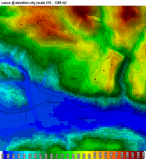
Below is the Elevation map of Lauco, which displays elevation range with different colors. Scale of the first map is from 319 to 1389 m (1047 to 4557 ft) with average elevation of 691.3 meters (=2268 ft) [note 1]
These maps also provides idea of topography and contour of this city, they are displayed at different zoom levels. More info about maps, scale and edge coordinates you can find below images.
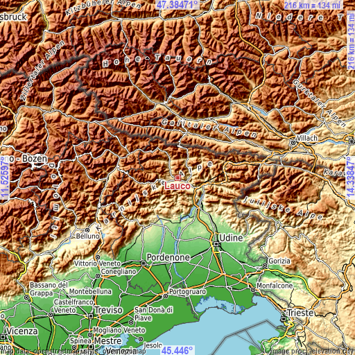
| \ | Map #1 | Topo.Map |
| Scale [m] | 319..1389 m | × |
| Scale [ft] | 1047..4557 ft | × |
| Average | 691.3 m = 2268 ft | × |
| Width | 6.74 km = 4.2 mi | 215.6 km = 134 mi |
| Height | 6.74 km = 4.2 mi | 215.6 km = 134 mi |
| ↑Max Latitude | 46.454254° | 47.38471° |
| Latitude at center | 46.42397° | 46.42397° |
| ↓Min Latitude | 46.393669° | 45.446° |
| ← Min Longitude | 12.888275° | 11.52597° |
| Longitude center | 12.93222° | 12.93222° |
| →Max Longitude | 12.976165° | 14.33847° |
Nearby cities:
Cities around Lauco sort by population:
• Tolmezzo elevation 312 m
7.3 km,  111°
111°
• Villa Santina 363 m
1.3 km,  207°
207°
• Arta Terme 487 m
9.2 km,  47°
47°
• Enemonzo-Quinis 389 m
4.4 km,  246°
246°
• Ovaro 542 m
8.3 km,  323°
323°
• Ampezzo 552 m
10.5 km,  264°
264°
• Cavazzo Carnico 282 m
10.4 km,  126°
126°
• Zuglio 419 m
8.1 km,  61°
61°
• Raveo 506 m
4.8 km,  283°
283°
• Preone 445 m
6 km,  236°
236°
• Chiaulis 423 m
6 km, 130°
• Mediis 477 m
8.7 km, 254°
Multilingual:
 En español:
Lauco elevación 741 m.
 En France:
Lauco élévation 741 m.


Sources and notes:
- [note 1] Map square and city borders are not equal. Map elevation data is calculated only from area inside that square.
- [src 1] Elevation data from geonames database provided with same terms of usage.
- [src 2] The elevation map of Lauco is generated using elevation data from NASA's 3 arcsec (90m) resolution SRTM data.
- [src 3] Base (background) map © OpenStreetMap contributors tiles are generated by Geofabrik and OpenTopoMap.
Copyright & License:
This Lauco Elevation Map is licensed under CC BY-SA. You may reuse any part from this page, if you give a proper credit by linking to this URL:
 More info on terms of use page.