Laurito elevation
Laurito (Campania, Provincia di Salerno), Italy elevation is 523 meters and Laurito elevation in feet is 1716 ft above sea level [src 1]. Laurito is a seat of a third-order administrative division (feature code) with elevation that is 201 meters (659 ft) bigger than average city elevation in Italy.
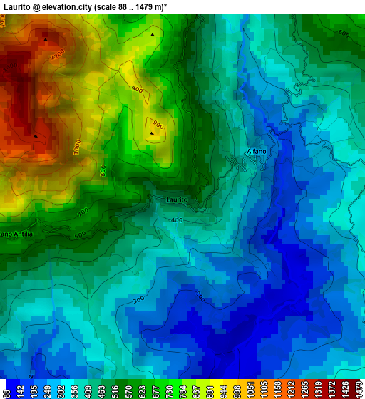
Below is the Elevation map of Laurito, which displays elevation range with different colors. Scale of the first map is from 88 to 1479 m (289 to 4852 ft) with average elevation of 486.3 meters (=1595 ft) [note 1]
These maps also provides idea of topography and contour of this city, they are displayed at different zoom levels. More info about maps, scale and edge coordinates you can find below images.
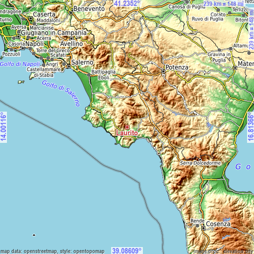
| \ | Map #1 | Topo.Map |
| Scale [m] | 88..1479 m | × |
| Scale [ft] | 289..4852 ft | × |
| Average | 486.3 m = 1595 ft | × |
| Width | 7.47 km = 4.6 mi | 239 km = 148.5 mi |
| Height | 7.47 km = 4.6 mi | 239 km = 148.5 mi |
| ↑Max Latitude | 40.202722° | 41.2352° |
| Latitude at center | 40.16915° | 40.16915° |
| ↓Min Latitude | 40.135561° | 39.08609° |
| ← Min Longitude | 15.363465° | 14.00116° |
| Longitude center | 15.40741° | 15.40741° |
| →Max Longitude | 15.451355° | 16.81366° |
Nearby cities:
Cities around Laurito sort by population:
• Novi Velia elevation 578 m
11.9 km,  299°
299°
• Rofrano 463 m
5.2 km,  20°
20°
• Caselle in Pittari 415 m
11.5 km,  87°
87°
• Torre Orsaia 287 m
6.9 km,  126°
126°
• Celle di Bulgheria 228 m
8.2 km,  182°
182°
• Alfano 296 m
1.7 km,  59°
59°
• Cannalonga 547 m
12.8 km,  310°
310°
• Futani 445 m
7.4 km,  254°
254°
• Roccagloriosa 371 m
7.4 km,  160°
160°
• Montano Antilia 714 m
3.8 km,  259°
259°
• Cuccaro Vetere 629 m
8.6 km,  266°
266°
• San Mauro la Bruca 426 m
11.2 km,  242°
242°
Multilingual:
 En español:
Laurito elevación 523 m.
 En France:
Laurito élévation 523 m.


Sources and notes:
- [note 1] Map square and city borders are not equal. Map elevation data is calculated only from area inside that square.
- [src 1] Elevation data from geonames database provided with same terms of usage.
- [src 2] The elevation map of Laurito is generated using elevation data from NASA's 3 arcsec (90m) resolution SRTM data.
- [src 3] Base (background) map © OpenStreetMap contributors tiles are generated by Geofabrik and OpenTopoMap.
Copyright & License:
This Laurito Elevation Map is licensed under CC BY-SA. You may reuse any part from this page, if you give a proper credit by linking to this URL:
 More info on terms of use page.