Lograto elevation
Lograto (Lombardy, Provincia di Brescia), Italy elevation is 111 meters and Lograto elevation in feet is 364 ft above sea level [src 1]. Lograto is a seat of a third-order administrative division (feature code) with elevation that is 211 meters (692 ft) smaller than average city elevation in Italy.
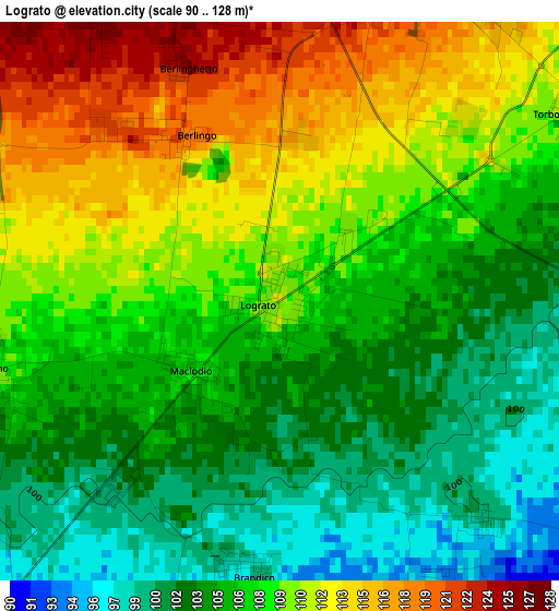
Below is the Elevation map of Lograto, which displays elevation range with different colors. Scale of the first map is from 90 to 128 m (295 to 420 ft) with average elevation of 107.4 meters (=352 ft) [note 1]
These maps also provides idea of topography and contour of this city, they are displayed at different zoom levels. More info about maps, scale and edge coordinates you can find below images.
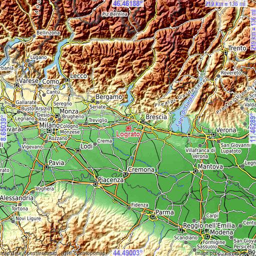
| \ | Map #1 | Topo.Map |
| Scale [m] | 90..128 m | × |
| Scale [ft] | 295..420 ft | × |
| Average | 107.4 m = 352 ft | × |
| Width | 6.85 km = 4.3 mi | 219.2 km = 136.2 mi |
| Height | 6.85 km = 4.3 mi | 219.2 km = 136.2 mi |
| ↑Max Latitude | 45.515382° | 46.46188° |
| Latitude at center | 45.48458° | 45.48458° |
| ↓Min Latitude | 45.453761° | 44.49003° |
| ← Min Longitude | 10.012695° | 8.65039° |
| Longitude center | 10.05664° | 10.05664° |
| →Max Longitude | 10.100585° | 11.46289° |
Nearby cities:
Cities around Lograto sort by population:
• Travagliato elevation 129 m
4.7 km,  22°
22°
• Torbole Casaglia 113 m
5.7 km,  56°
56°
• Trenzano 109 m
3.7 km,  257°
257°
• Capriano del Colle 97 m
6 km,  100°
100°
• Azzano Mella 93 m
5.8 km,  125°
125°
• Mairano 94 m
4.4 km,  156°
156°
• Berlingo 121 m
2.7 km,  319°
319°
• Brandico 100 m
3.4 km,  185°
185°
• Maclodio 107 m
1.4 km,  236°
236°
• Pievedizio 100 m
3.6 km,  137°
137°
• Corzano 94 m
5.9 km,  220°
220°
• Longhena 93 m
5.2 km,  177°
177°
Multilingual:
 En español:
Lograto elevación 111 m.
 En France:
Lograto élévation 111 m.


Sources and notes:
- [note 1] Map square and city borders are not equal. Map elevation data is calculated only from area inside that square.
- [src 1] Elevation data from geonames database provided with same terms of usage.
- [src 2] The elevation map of Lograto is generated using elevation data from NASA's 3 arcsec (90m) resolution SRTM data.
- [src 3] Base (background) map © OpenStreetMap contributors tiles are generated by Geofabrik and OpenTopoMap.
Copyright & License:
This Lograto Elevation Map is licensed under CC BY-SA. You may reuse any part from this page, if you give a proper credit by linking to this URL:
 More info on terms of use page.