Lonigo elevation
Lonigo (Veneto, Provincia di Vicenza), Italy elevation is 25 meters and Lonigo elevation in feet is 82 ft above sea level [src 1]. Lonigo is a seat of a third-order administrative division (feature code) with elevation that is 297 meters (974 ft) smaller than average city elevation in Italy.
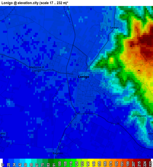
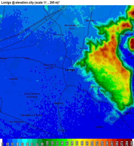
Below is the Elevation map of Lonigo, which displays elevation range with different colors. Scale of the first map is from 17 to 232 m (56 to 761 ft) with average elevation of 43.7 meters (=143 ft) [note 1]
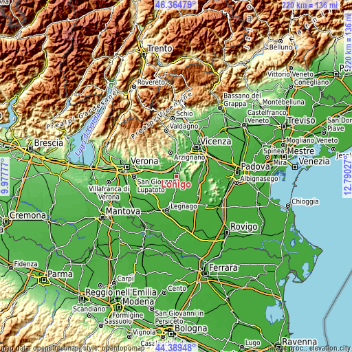
These maps also provides idea of topography and contour of this city, they are displayed at different zoom levels. More info about maps, scale and edge coordinates you can find below images.
| \ | Map #1 | Map #2 | Topo.Map |
| Scale [m] | 17..232 m | 11..295 m | × |
| Scale [ft] | 56..761 ft | 36..968 ft | × |
| Average | 43.7 m = 143 ft | 50.5 m = 166 ft | × |
| Width | 6.86 km = 4.3 mi | 13.73 km = 8.5 mi | 219.6 km = 136.5 mi |
| Height | 6.86 km = 4.3 mi | 13.73 km = 8.5 mi | 219.6 km = 136.5 mi |
| ↑Max Latitude | 45.416616° | 45.447455° | 46.36479° |
| Latitude at center | 45.38576° | 45.38576° | 45.38576° |
| ↓Min Latitude | 45.354887° | 45.323998° | 44.38948° |
| ← Min Longitude | 11.340075° | 11.296129° | 9.97777° |
| Longitude center | 11.38402° | 11.38402° | 11.38402° |
| →Max Longitude | 11.427965° | 11.471911° | 12.79027° |
Nearby cities:
Cities around Lonigo sort by population:
• Arcole elevation 27 m
8 km,  250°
250°
• Santo Stefano-Bonaldo 25 m
4.6 km,  243°
243°
• Meledo 42 m
6.3 km,  22°
22°
• San Gregorio 24 m
8.2 km,  234°
234°
• Locara 29 m
5 km,  306°
306°
• Gazzolo-Volpino 28 m
5.7 km,  258°
258°
• Sarego 34 m
2.8 km,  29°
29°
• Monticello di Fara 38 m
4.8 km,  5°
5°
• Pederiva 46 m
7.6 km,  57°
57°
• Alonte 37 m
4 km,  123°
123°
• San Germano dei Berici 64 m
7 km,  75°
75°
• Grancona 168 m
6.6 km,  52°
52°
Multilingual:
 En español:
Lonigo elevación 25 m.
 En France:
Lonigo élévation 25 m.


Sources and notes:
- [note 1] Map square and city borders are not equal. Map elevation data is calculated only from area inside that square.
- [src 1] Elevation data from geonames database provided with same terms of usage.
- [src 2] The elevation map of Lonigo is generated using elevation data from NASA's 3 arcsec (90m) resolution SRTM data.
- [src 3] Base (background) map © OpenStreetMap contributors tiles are generated by Geofabrik and OpenTopoMap.
Copyright & License:
This Lonigo Elevation Map is licensed under CC BY-SA. You may reuse any part from this page, if you give a proper credit by linking to this URL:
 More info on terms of use page.