Magenta elevation
Magenta (Lombardy, Città metropolitana di Milano), Italy elevation is 139 meters and Magenta elevation in feet is 456 ft above sea level [src 1]. Magenta is a seat of a third-order administrative division (feature code) with elevation that is 183 meters (600 ft) smaller than average city elevation in Italy.
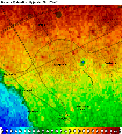
Below is the Elevation map of Magenta, which displays elevation range with different colors. Scale of the first map is from 106 to 153 m (348 to 502 ft) with average elevation of 135.4 meters (=444 ft) [note 1]
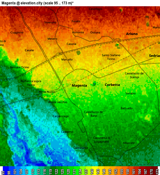
These maps also provides idea of topography and contour of this city, they are displayed at different zoom levels. More info about maps, scale and edge coordinates you can find below images.
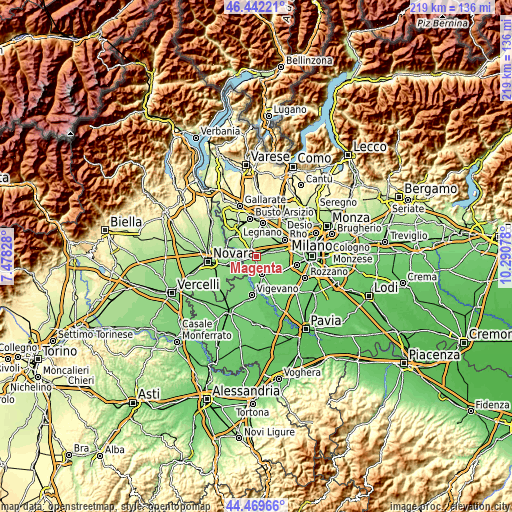
| \ | Map #1 | Map #2 | Topo.Map |
| Scale [m] | 106..153 m | 95..173 m | × |
| Scale [ft] | 348..502 ft | 312..568 ft | × |
| Average | 135.4 m = 444 ft | 134.3 m = 441 ft | × |
| Width | 6.85 km = 4.3 mi | 13.71 km = 8.5 mi | 219.3 km = 136.3 mi |
| Height | 6.85 km = 4.3 mi | 13.71 km = 8.5 mi | 219.3 km = 136.3 mi |
| ↑Max Latitude | 45.495373° | 45.526168° | 46.44221° |
| Latitude at center | 45.46456° | 45.46456° | 45.46456° |
| ↓Min Latitude | 45.433731° | 45.402884° | 44.46966° |
| ← Min Longitude | 8.840585° | 8.796639° | 7.47828° |
| Longitude center | 8.88453° | 8.88453° | 8.88453° |
| →Max Longitude | 8.928475° | 8.972421° | 10.29078° |
Nearby cities:
Cities around Magenta sort by population:
• Corbetta elevation 139 m
2.7 km,  83°
83°
• Santo Stefano Ticino 149 m
3.4 km,  45°
45°
• Marcallo 147 m
2.3 km,  334°
334°
• Robecco sul Naviglio 128 m
3.1 km,  178°
178°
• Ossona 157 m
4.8 km,  8°
8°
• Boffalora Sopra Ticino 138 m
4.2 km,  274°
274°
• Mesero 154 m
4.8 km, 331°
• Cassinetta di Lugagnano 124 m
5 km,  160°
160°
• Bernate Ticino 132 m
5.4 km,  286°
286°
• Cerello-Battuello 130 m
4.1 km,  118°
118°
• Casone 153 m
3.8 km,  350°
350°
• Casate 149 m
5.4 km,  304°
304°
Multilingual:
 En español:
Magenta elevación 139 m.
 En France:
Magenta élévation 139 m.


Sources and notes:
- [note 1] Map square and city borders are not equal. Map elevation data is calculated only from area inside that square.
- [src 1] Elevation data from geonames database provided with same terms of usage.
- [src 2] The elevation map of Magenta is generated using elevation data from NASA's 3 arcsec (90m) resolution SRTM data.
- [src 3] Base (background) map © OpenStreetMap contributors tiles are generated by Geofabrik and OpenTopoMap.
Copyright & License:
This Magenta Elevation Map is licensed under CC BY-SA. You may reuse any part from this page, if you give a proper credit by linking to this URL:
 More info on terms of use page.