Malcesine elevation
Malcesine (Veneto, Provincia di Verona), Italy elevation is 88 meters and Malcesine elevation in feet is 289 ft above sea level [src 1]. Malcesine is a seat of a third-order administrative division (feature code) with elevation that is 234 meters (768 ft) smaller than average city elevation in Italy.
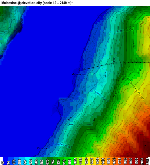
Below is the Elevation map of Malcesine, which displays elevation range with different colors. Scale of the first map is from 12 to 2149 m (39 to 7051 ft) with average elevation of 464.3 meters (=1523 ft) [note 1]
These maps also provides idea of topography and contour of this city, they are displayed at different zoom levels. More info about maps, scale and edge coordinates you can find below images.
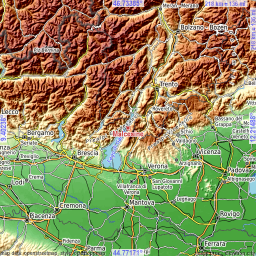
| \ | Map #1 | Topo.Map |
| Scale [m] | 12..2149 m | × |
| Scale [ft] | 39..7051 ft | × |
| Average | 464.3 m = 1523 ft | × |
| Width | 6.82 km = 4.2 mi | 218.2 km = 135.6 mi |
| Height | 6.82 km = 4.2 mi | 218.2 km = 135.6 mi |
| ↑Max Latitude | 45.79205° | 46.73385° |
| Latitude at center | 45.7614° | 45.7614° |
| ↓Min Latitude | 45.730733° | 44.77171° |
| ← Min Longitude | 10.764685° | 9.40238° |
| Longitude center | 10.80863° | 10.80863° |
| →Max Longitude | 10.852575° | 12.21488° |
Nearby cities:
Cities around Malcesine sort by population:
• Magugnano elevation 108 m
7.6 km,  208°
208°
• Brenzone 81 m
7.8 km, 208°
• Avio 140 m
10.6 km,  106°
106°
• Brentonico 701 m
13 km,  60°
60°
• Sabbionara 158 m
11.8 km,  100°
100°
• Limone sul Garda 87 m
6 km,  348°
348°
• Molina di Ledro 633 m
12.5 km, 347°
• Gardola 608 m
7.3 km,  252°
252°
• Rivalta 130 m
13.3 km,  150°
150°
• Pieve 418 m
4 km,  288°
288°
• Ferrara di Monte Baldo 958 m
10.5 km,  158°
158°
• Torbole sul Garda 69 m
13.1 km,  23°
23°
Multilingual:
 En español:
Malcesine elevación 88 m.
 En France:
Malcesine élévation 88 m.
 Auf Deutsch:
Malcesine höhe über dem Meeresspiegel ist 88 m.

Sources and notes:
- [note 1] Map square and city borders are not equal. Map elevation data is calculated only from area inside that square.
- [src 1] Elevation data from geonames database provided with same terms of usage.
- [src 2] The elevation map of Malcesine is generated using elevation data from NASA's 3 arcsec (90m) resolution SRTM data.
- [src 3] Base (background) map © OpenStreetMap contributors tiles are generated by Geofabrik and OpenTopoMap.
Copyright & License:
This Malcesine Elevation Map is licensed under CC BY-SA. You may reuse any part from this page, if you give a proper credit by linking to this URL:
 More info on terms of use page.