Maniago elevation
Maniago (Friuli Venezia Giulia, Provincia di Pordenone), Italy elevation is 285 meters and Maniago elevation in feet is 935 ft above sea level [src 1]. Maniago is a seat of a third-order administrative division (feature code) with elevation that is 37 meters (121 ft) smaller than average city elevation in Italy.
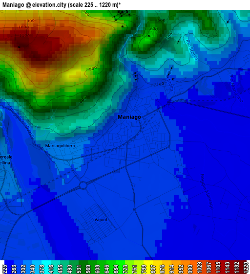
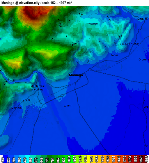
Below is the Elevation map of Maniago, which displays elevation range with different colors. Scale of the first map is from 225 to 1220 m (738 to 4003 ft) with average elevation of 400.8 meters (=1315 ft) [note 1]
These maps also provides idea of topography and contour of this city, they are displayed at different zoom levels. More info about maps, scale and edge coordinates you can find below images.
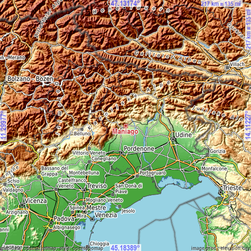
| \ | Map #1 | Map #2 | Topo.Map |
| Scale [m] | 225..1220 m | 152..1997 m | × |
| Scale [ft] | 738..4003 ft | 499..6552 ft | × |
| Average | 400.8 m = 1315 ft | 432.2 m = 1418 ft | × |
| Width | 6.77 km = 4.2 mi | 13.54 km = 8.4 mi | 216.6 km = 134.6 mi |
| Height | 6.77 km = 4.2 mi | 13.54 km = 8.4 mi | 216.6 km = 134.6 mi |
| ↑Max Latitude | 46.196867° | 46.227276° | 47.13174° |
| Latitude at center | 46.16644° | 46.16644° | 46.16644° |
| ↓Min Latitude | 46.135997° | 46.105536° | 45.18389° |
| ← Min Longitude | 12.662075° | 12.618129° | 11.29977° |
| Longitude center | 12.70602° | 12.70602° | 12.70602° |
| →Max Longitude | 12.749965° | 12.793911° | 14.11227° |
Nearby cities:
Cities around Maniago sort by population:
• Montereale Valcellina elevation 304 m
4.8 km,  249°
249°
• Vajont 286 m
2.5 km,  197°
197°
• Fanna 263 m
4 km,  60°
60°
• Cavasso Nuovo 274 m
6 km, 58°
• Marsure 218 m
11.7 km,  226°
226°
• Meduno 284 m
9 km,  52°
52°
• Arba 210 m
6.9 km,  109°
109°
• Sequals 210 m
9.6 km,  91°
91°
• Vivaro 131 m
11.5 km,  150°
150°
• Barcis 413 m
11.5 km,  283°
283°
• Frisanco 504 m
5.3 km,  16°
16°
• Andreis 461 m
8.1 km,  298°
298°
Multilingual:
 En español:
Maniago elevación 285 m.
 En France:
Maniago élévation 285 m.


Sources and notes:
- [note 1] Map square and city borders are not equal. Map elevation data is calculated only from area inside that square.
- [src 1] Elevation data from geonames database provided with same terms of usage.
- [src 2] The elevation map of Maniago is generated using elevation data from NASA's 3 arcsec (90m) resolution SRTM data.
- [src 3] Base (background) map © OpenStreetMap contributors tiles are generated by Geofabrik and OpenTopoMap.
Copyright & License:
This Maniago Elevation Map is licensed under CC BY-SA. You may reuse any part from this page, if you give a proper credit by linking to this URL:
 More info on terms of use page.