Marlengo elevation
Marlengo (Trentino-Alto Adige, Bolzano), Italy elevation is 288 meters and Marlengo elevation in feet is 945 ft above sea level [src 1]. Marlengo is a seat of a third-order administrative division (feature code) with elevation that is 34 meters (112 ft) smaller than average city elevation in Italy.
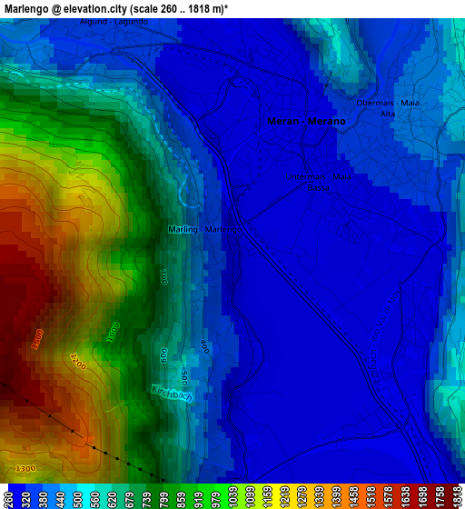
Below is the Elevation map of Marlengo, which displays elevation range with different colors. Scale of the first map is from 260 to 1818 m (853 to 5965 ft) with average elevation of 589.7 meters (=1935 ft) [note 1]
These maps also provides idea of topography and contour of this city, they are displayed at different zoom levels. More info about maps, scale and edge coordinates you can find below images.
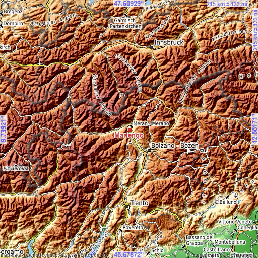
| \ | Map #1 | Topo.Map |
| Scale [m] | 260..1818 m | × |
| Scale [ft] | 853..5965 ft | × |
| Average | 589.7 m = 1935 ft | × |
| Width | 6.71 km = 4.2 mi | 214.7 km = 133.4 mi |
| Height | 6.71 km = 4.2 mi | 214.6 km = 133.3 mi |
| ↑Max Latitude | 46.682777° | 47.60929° |
| Latitude at center | 46.65262° | 46.65262° |
| ↓Min Latitude | 46.622447° | 45.67872° |
| ← Min Longitude | 11.101515° | 9.73921° |
| Longitude center | 11.14546° | 11.14546° |
| →Max Longitude | 11.189405° | 12.55171° |
Nearby cities:
Cities around Marlengo sort by population:
• Merano elevation 310 m
2 km,  31°
31°
• Lana 285 m
4.6 km,  169°
169°
• Lagundo 332 m
3.5 km,  334°
334°
• Scena - Schenna 574 m
5.2 km,  36°
36°
• Sinigo 273 m
3.2 km,  127°
127°
• Postal 271 m
6 km,  142°
142°
• Scena 574 m
5.2 km, 39°
• Tirolo 600 m
4.3 km,  8°
8°
• Cermes 281 m
2.2 km,  177°
177°
• Caines - Kuens 635 m
5.6 km,  19°
19°
• Caines 579 m
5.4 km, 21°
• Avelengo 1299 m
6.1 km,  97°
97°
Multilingual:
 En español:
Marlengo elevación 288 m.
 En France:
Marlengo élévation 288 m.


Sources and notes:
- [note 1] Map square and city borders are not equal. Map elevation data is calculated only from area inside that square.
- [src 1] Elevation data from geonames database provided with same terms of usage.
- [src 2] The elevation map of Marlengo is generated using elevation data from NASA's 3 arcsec (90m) resolution SRTM data.
- [src 3] Base (background) map © OpenStreetMap contributors tiles are generated by Geofabrik and OpenTopoMap.
Copyright & License:
This Marlengo Elevation Map is licensed under CC BY-SA. You may reuse any part from this page, if you give a proper credit by linking to this URL:
 More info on terms of use page.