Marone elevation
Marone (Lombardy, Provincia di Brescia), Italy elevation is 216 meters and Marone elevation in feet is 709 ft above sea level [src 1]. Marone is a seat of a third-order administrative division (feature code) with elevation that is 106 meters (348 ft) smaller than average city elevation in Italy.
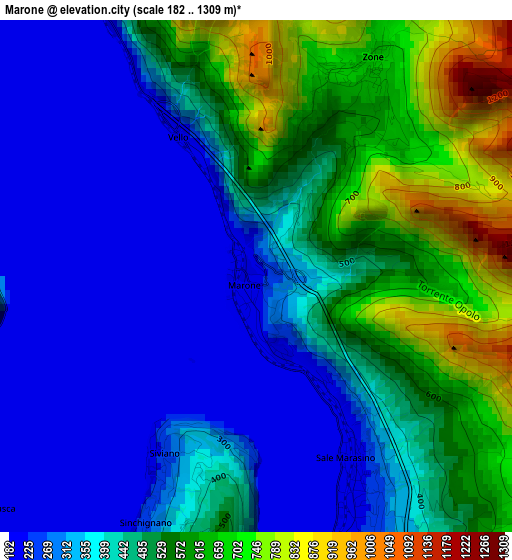
Below is the Elevation map of Marone, which displays elevation range with different colors. Scale of the first map is from 182 to 1309 m (597 to 4295 ft) with average elevation of 431.5 meters (=1416 ft) [note 1]
These maps also provides idea of topography and contour of this city, they are displayed at different zoom levels. More info about maps, scale and edge coordinates you can find below images.
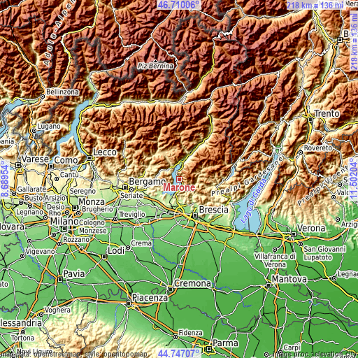
| \ | Map #1 | Topo.Map |
| Scale [m] | 182..1309 m | × |
| Scale [ft] | 597..4295 ft | × |
| Average | 431.5 m = 1416 ft | × |
| Width | 6.82 km = 4.2 mi | 218.3 km = 135.6 mi |
| Height | 6.82 km = 4.2 mi | 218.3 km = 135.6 mi |
| ↑Max Latitude | 45.767853° | 46.71006° |
| Latitude at center | 45.73719° | 45.73719° |
| ↓Min Latitude | 45.70651° | 44.74707° |
| ← Min Longitude | 10.051845° | 8.68954° |
| Longitude center | 10.09579° | 10.09579° |
| →Max Longitude | 10.139735° | 11.50204° |
Nearby cities:
Cities around Marone sort by population:
• Pisogne elevation 190 m
7.9 km,  8°
8°
• Sale Marasino 217 m
3.7 km,  159°
159°
• Tavernola Bergamasca 254 m
5.1 km,  231°
231°
• Sulzano 205 m
5.6 km,  176°
176°
• Castro 199 m
7.8 km,  342°
342°
• Solto Collina 448 m
7.4 km,  312°
312°
• Zone 680 m
3.3 km,  28°
28°
• Riva di Solto 195 m
6 km, 313°
• Fonteno 655 m
6.4 km,  291°
291°
• Vigolo 606 m
5.9 km,  246°
246°
• Siviano 262 m
2.8 km,  205°
205°
• Parzanica 764 m
4.7 km,  272°
272°
Multilingual:
 En español:
Marone elevación 216 m.
 En France:
Marone élévation 216 m.


Sources and notes:
- [note 1] Map square and city borders are not equal. Map elevation data is calculated only from area inside that square.
- [src 1] Elevation data from geonames database provided with same terms of usage.
- [src 2] The elevation map of Marone is generated using elevation data from NASA's 3 arcsec (90m) resolution SRTM data.
- [src 3] Base (background) map © OpenStreetMap contributors tiles are generated by Geofabrik and OpenTopoMap.
Copyright & License:
This Marone Elevation Map is licensed under CC BY-SA. You may reuse any part from this page, if you give a proper credit by linking to this URL:
 More info on terms of use page.