Masera elevation
Masera (Piedmont, Provincia Verbano-Cusio-Ossola), Italy elevation is 307 meters and Masera elevation in feet is 1007 ft above sea level [src 1]. Masera is a seat of a third-order administrative division (feature code) with elevation that is 15 meters (49 ft) smaller than average city elevation in Italy.
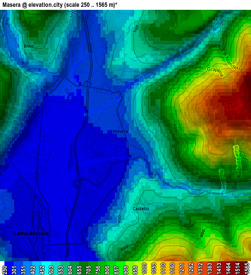
Below is the Elevation map of Masera, which displays elevation range with different colors. Scale of the first map is from 250 to 1565 m (820 to 5135 ft) with average elevation of 558.5 meters (=1832 ft) [note 1]
These maps also provides idea of topography and contour of this city, they are displayed at different zoom levels. More info about maps, scale and edge coordinates you can find below images.
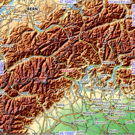
| \ | Map #1 | Topo.Map |
| Scale [m] | 250..1565 m | × |
| Scale [ft] | 820..5135 ft | × |
| Average | 558.5 m = 1832 ft | × |
| Width | 6.77 km = 4.2 mi | 216.7 km = 134.7 mi |
| Height | 6.77 km = 4.2 mi | 216.7 km = 134.7 mi |
| ↑Max Latitude | 46.169322° | 47.10467° |
| Latitude at center | 46.13888° | 46.13888° |
| ↓Min Latitude | 46.108421° | 45.15585° |
| ← Min Longitude | 8.281315° | 6.91901° |
| Longitude center | 8.32526° | 8.32526° |
| →Max Longitude | 8.369205° | 9.73151° |
Nearby cities:
Cities around Masera sort by population:
• Domodossola elevation 284 m
3.5 km,  224°
224°
• Villadossola 252 m
8.8 km,  210°
210°
• Crevoladossola 300 m
2.4 km,  296°
296°
• Varzo 580 m
9.4 km,  323°
323°
• Santa Maria Maggiore 832 m
10.5 km,  91°
91°
• Crodo 506 m
8.7 km,  358°
358°
• Beura 250 m
6.9 km,  197°
197°
• Druogno 831 m
8.3 km, 93°
• Trontano 519 m
1.9 km,  161°
161°
• Montescheno 554 m
10.8 km, 221°
• San Lorenzo 986 m
9.7 km,  262°
262°
• Montecrestese 476 m
2.8 km,  1°
1°
Multilingual:
 En español:
Masera elevación 307 m.
 En France:
Masera élévation 307 m.


Sources and notes:
- [note 1] Map square and city borders are not equal. Map elevation data is calculated only from area inside that square.
- [src 1] Elevation data from geonames database provided with same terms of usage.
- [src 2] The elevation map of Masera is generated using elevation data from NASA's 3 arcsec (90m) resolution SRTM data.
- [src 3] Base (background) map © OpenStreetMap contributors tiles are generated by Geofabrik and OpenTopoMap.
Copyright & License:
This Masera Elevation Map is licensed under CC BY-SA. You may reuse any part from this page, if you give a proper credit by linking to this URL:
 More info on terms of use page.