Massa Martana elevation
Massa Martana (Umbria, Provincia di Perugia), Italy elevation is 340 meters and Massa Martana elevation in feet is 1115 ft above sea level [src 1]. Massa Martana is a seat of a third-order administrative division (feature code) with elevation that is 18 meters (59 ft) bigger than average city elevation in Italy.
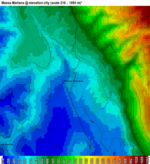
Below is the Elevation map of Massa Martana, which displays elevation range with different colors. Scale of the first map is from 216 to 1093 m (709 to 3586 ft) with average elevation of 437.4 meters (=1435 ft) [note 1]
These maps also provides idea of topography and contour of this city, they are displayed at different zoom levels. More info about maps, scale and edge coordinates you can find below images.
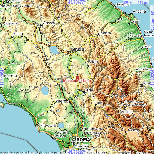
| \ | Map #1 | Topo.Map |
| Scale [m] | 216..1093 m | × |
| Scale [ft] | 709..3586 ft | × |
| Average | 437.4 m = 1435 ft | × |
| Width | 7.17 km = 4.5 mi | 229.6 km = 142.7 mi |
| Height | 7.17 km = 4.5 mi | 229.5 km = 142.6 mi |
| ↑Max Latitude | 42.80537° | 43.79677° |
| Latitude at center | 42.77312° | 42.77312° |
| ↓Min Latitude | 42.740854° | 41.73227° |
| ← Min Longitude | 12.481845° | 11.11954° |
| Longitude center | 12.52579° | 12.52579° |
| →Max Longitude | 12.569735° | 13.93204° |
Nearby cities:
Cities around Massa Martana sort by population:
• Todi elevation 340 m
9.3 km,  273°
273°
• Giano dell'Umbria 531 m
8 km,  32°
32°
• Acquasparta 328 m
9.4 km,  171°
171°
• Bastardo 285 m
11.3 km,  14°
14°
• San Martino in Trignano 316 m
12.2 km,  106°
106°
• Ponterio-Pian di Porto 149 m
10.2 km,  292°
292°
• Pantalla 166 m
15.2 km,  316°
316°
• Montecastrilli 379 m
13.9 km,  192°
192°
• Bruna 239 m
14.3 km,  68°
68°
• San Terenziano 523 m
11.3 km,  337°
337°
• Casteltodino 393 m
12 km, 190°
• Castel Ritaldi 298 m
13.3 km, 65°
Multilingual:
 En español:
Massa Martana elevación 340 m.
 En France:
Massa Martana élévation 340 m.
 Auf Deutsch:
Massa Martana höhe über dem Meeresspiegel ist 340 m.

Sources and notes:
- [note 1] Map square and city borders are not equal. Map elevation data is calculated only from area inside that square.
- [src 1] Elevation data from geonames database provided with same terms of usage.
- [src 2] The elevation map of Massa Martana is generated using elevation data from NASA's 3 arcsec (90m) resolution SRTM data.
- [src 3] Base (background) map © OpenStreetMap contributors tiles are generated by Geofabrik and OpenTopoMap.
Copyright & License:
This Massa Martana Elevation Map is licensed under CC BY-SA. You may reuse any part from this page, if you give a proper credit by linking to this URL:
 More info on terms of use page.