Massazza elevation
Massazza (Piedmont, Provincia di Biella), Italy elevation is 226 meters and Massazza elevation in feet is 741 ft above sea level [src 1]. Massazza is a seat of a third-order administrative division (feature code) with elevation that is 96 meters (315 ft) smaller than average city elevation in Italy.
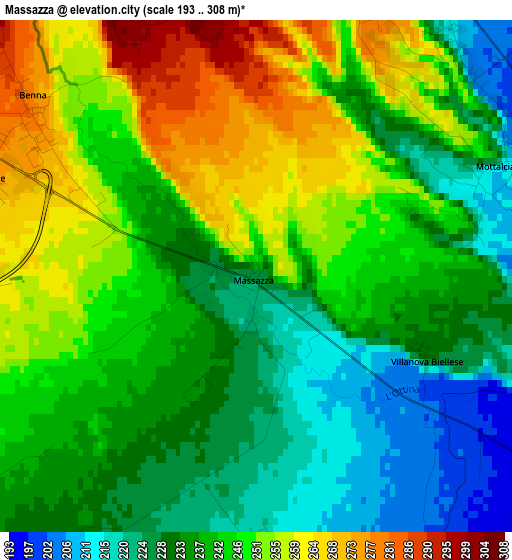
Below is the Elevation map of Massazza, which displays elevation range with different colors. Scale of the first map is from 193 to 308 m (633 to 1010 ft) with average elevation of 241.1 meters (=791 ft) [note 1]
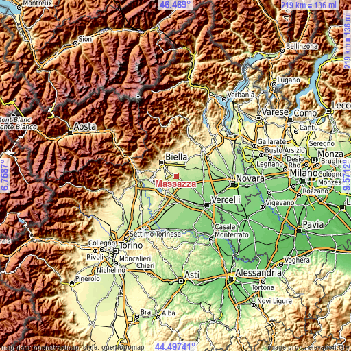
These maps also provides idea of topography and contour of this city, they are displayed at different zoom levels. More info about maps, scale and edge coordinates you can find below images.
| \ | Map #1 | Topo.Map |
| Scale [m] | 193..308 m | × |
| Scale [ft] | 633..1010 ft | × |
| Average | 241.1 m = 791 ft | × |
| Width | 6.85 km = 4.3 mi | 219.2 km = 136.2 mi |
| Height | 6.85 km = 4.3 mi | 219.2 km = 136.2 mi |
| ↑Max Latitude | 45.522628° | 46.469° |
| Latitude at center | 45.49183° | 45.49183° |
| ↓Min Latitude | 45.461015° | 44.49741° |
| ← Min Longitude | 8.121005° | 6.7587° |
| Longitude center | 8.16495° | 8.16495° |
| →Max Longitude | 8.208895° | 9.5712° |
Nearby cities:
Cities around Massazza sort by population:
• Candelo elevation 331 m
7.1 km,  320°
320°
• Sandigliano 325 m
7.7 km,  296°
296°
• Vergnasco 270 m
6.2 km,  266°
266°
• Verrone 283 m
4.3 km, 295°
• Benna 282 m
4.1 km,  309°
309°
• Buronzo 183 m
8 km,  99°
99°
• Salussola 260 m
6.6 km,  219°
219°
• Mottalciata 209 m
3.7 km,  75°
75°
• Cerrione 260 m
7.9 km,  251°
251°
• Castelletto Cervo 204 m
5.7 km,  55°
55°
• Villanova Biellese 231 m
2.6 km,  116°
116°
• Gifflenga 185 m
5.2 km,  88°
88°
Multilingual:
 En español:
Massazza elevación 226 m.
 En France:
Massazza élévation 226 m.
 Auf Deutsch:
Massazza höhe über dem Meeresspiegel ist 226 m.

Sources and notes:
- [note 1] Map square and city borders are not equal. Map elevation data is calculated only from area inside that square.
- [src 1] Elevation data from geonames database provided with same terms of usage.
- [src 2] The elevation map of Massazza is generated using elevation data from NASA's 3 arcsec (90m) resolution SRTM data.
- [src 3] Base (background) map © OpenStreetMap contributors tiles are generated by Geofabrik and OpenTopoMap.
Copyright & License:
This Massazza Elevation Map is licensed under CC BY-SA. You may reuse any part from this page, if you give a proper credit by linking to this URL:
 More info on terms of use page.