Massimeno elevation
Massimeno (Trentino-Alto Adige, Provincia autonoma di Trento), Italy elevation is 869 meters and Massimeno elevation in feet is 2851 ft above sea level [src 1]. Massimeno is a seat of a third-order administrative division (feature code) with elevation that is 547 meters (1795 ft) bigger than average city elevation in Italy.
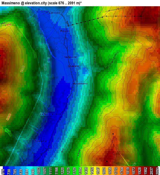
Below is the Elevation map of Massimeno, which displays elevation range with different colors. Scale of the first map is from 676 to 2091 m (2218 to 6860 ft) with average elevation of 1261.3 meters (=4138 ft) [note 1]
These maps also provides idea of topography and contour of this city, they are displayed at different zoom levels. More info about maps, scale and edge coordinates you can find below images.
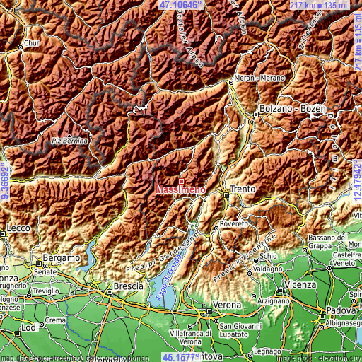
| \ | Map #1 | Topo.Map |
| Scale [m] | 676..2091 m | × |
| Scale [ft] | 2218..6860 ft | × |
| Average | 1261.3 m = 4138 ft | × |
| Width | 6.77 km = 4.2 mi | 216.7 km = 134.7 mi |
| Height | 6.77 km = 4.2 mi | 216.7 km = 134.7 mi |
| ↑Max Latitude | 46.171141° | 47.10646° |
| Latitude at center | 46.1407° | 46.1407° |
| ↓Min Latitude | 46.110242° | 45.1577° |
| ← Min Longitude | 10.729225° | 9.36692° |
| Longitude center | 10.77317° | 10.77317° |
| →Max Longitude | 10.817115° | 12.17942° |
Nearby cities:
Cities around Massimeno sort by population:
• Pinzolo elevation 778 m
2.2 km,  341°
341°
• Spiazzo 651 m
4.9 km,  212°
212°
• Carisolo 797 m
3.3 km, 340°
• Giustino 773 m
1.2 km, 340°
• Caderzone Terme 719 m
1.8 km,  226°
226°
• Strembo 727 m
2.8 km,  217°
217°
• Ragoli 569 m
9.6 km,  177°
177°
• Villa Rendena 610 m
9.9 km, 208°
• Bocenago 754 m
2.7 km,  204°
204°
• Pelugo 659 m
6.9 km, 213°
• Preore 529 m
10.5 km,  185°
185°
• Montagne 943 m
9.3 km, 190°
Multilingual:
 En español:
Massimeno elevación 869 m.
 En France:
Massimeno élévation 869 m.
 Auf Deutsch:
Massimeno höhe über dem Meeresspiegel ist 869 m.

Sources and notes:
- [note 1] Map square and city borders are not equal. Map elevation data is calculated only from area inside that square.
- [src 1] Elevation data from geonames database provided with same terms of usage.
- [src 2] The elevation map of Massimeno is generated using elevation data from NASA's 3 arcsec (90m) resolution SRTM data.
- [src 3] Base (background) map © OpenStreetMap contributors tiles are generated by Geofabrik and OpenTopoMap.
Copyright & License:
This Massimeno Elevation Map is licensed under CC BY-SA. You may reuse any part from this page, if you give a proper credit by linking to this URL:
 More info on terms of use page.