Mathi elevation
Mathi (Piedmont, Torino), Italy elevation is 406 meters and Mathi elevation in feet is 1332 ft above sea level [src 1]. Mathi is a seat of a third-order administrative division (feature code) with elevation that is 84 meters (276 ft) bigger than average city elevation in Italy.
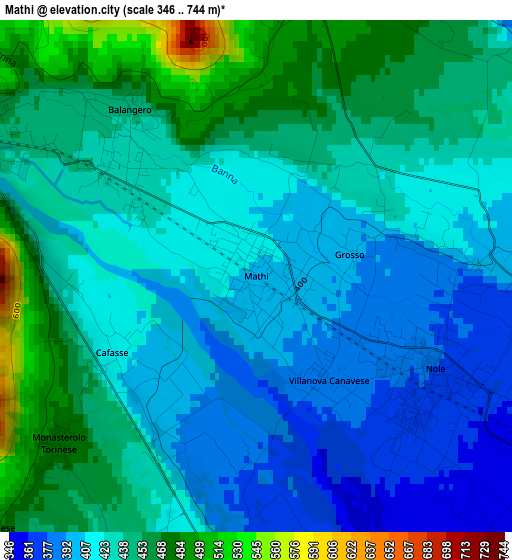
Below is the Elevation map of Mathi, which displays elevation range with different colors. Scale of the first map is from 346 to 744 m (1135 to 2441 ft) with average elevation of 428.2 meters (=1405 ft) [note 1]
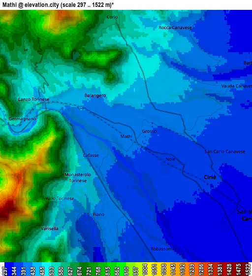
These maps also provides idea of topography and contour of this city, they are displayed at different zoom levels. More info about maps, scale and edge coordinates you can find below images.
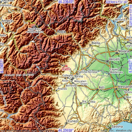
| \ | Map #1 | Map #2 | Topo.Map |
| Scale [m] | 346..744 m | 297..1522 m | × |
| Scale [ft] | 1135..2441 ft | 974..4993 ft | × |
| Average | 428.2 m = 1405 ft | 507.1 m = 1664 ft | × |
| Width | 6.88 km = 4.3 mi | 13.76 km = 8.6 mi | 220.1 km = 136.8 mi |
| Height | 6.88 km = 4.3 mi | 13.76 km = 8.6 mi | 220.1 km = 136.8 mi |
| ↑Max Latitude | 45.286077° | 45.316987° | 46.23645° |
| Latitude at center | 45.25515° | 45.25515° | 45.25515° |
| ↓Min Latitude | 45.224206° | 45.193246° | 44.25659° |
| ← Min Longitude | 7.498075° | 7.454129° | 6.13577° |
| Longitude center | 7.54202° | 7.54202° | 7.54202° |
| →Max Longitude | 7.585965° | 7.629911° | 8.94827° |
Nearby cities:
Cities around Mathi sort by population:
• Ciriè elevation 350 m
5.2 km,  115°
115°
• Nole 377 m
2.6 km, 124°
• Lanzo Torinese 488 m
5.2 km,  297°
297°
• San Carlo Canavese 364 m
5.1 km,  103°
103°
• Balangero 436 m
2.4 km,  312°
312°
• Cafasse 410 m
2 km,  248°
248°
• Fiano 427 m
4.5 km,  196°
196°
• Monasterolo 479 m
3.4 km,  230°
230°
• Villanova Canavese 387 m
1.5 km,  148°
148°
• Germagnano 484 m
5.8 km,  278°
278°
• Grosso 395 m
1.2 km,  83°
83°
• Vallo Torinese 486 m
5 km, 225°
Multilingual:
 En español:
Mathi elevación 406 m.
 En France:
Mathi élévation 406 m.


Sources and notes:
- [note 1] Map square and city borders are not equal. Map elevation data is calculated only from area inside that square.
- [src 1] Elevation data from geonames database provided with same terms of usage.
- [src 2] The elevation map of Mathi is generated using elevation data from NASA's 3 arcsec (90m) resolution SRTM data.
- [src 3] Base (background) map © OpenStreetMap contributors tiles are generated by Geofabrik and OpenTopoMap.
Copyright & License:
This Mathi Elevation Map is licensed under CC BY-SA. You may reuse any part from this page, if you give a proper credit by linking to this URL:
 More info on terms of use page.