Mondavio elevation
Mondavio (The Marches, Provincia di Pesaro e Urbino), Italy elevation is 248 meters and Mondavio elevation in feet is 814 ft above sea level [src 1]. Mondavio is a seat of a third-order administrative division (feature code) with elevation that is 74 meters (243 ft) smaller than average city elevation in Italy.
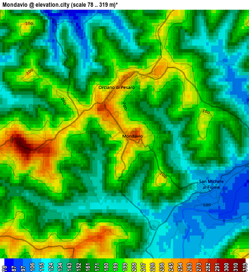
Below is the Elevation map of Mondavio, which displays elevation range with different colors. Scale of the first map is from 78 to 319 m (256 to 1047 ft) with average elevation of 166.4 meters (=546 ft) [note 1]
These maps also provides idea of topography and contour of this city, they are displayed at different zoom levels. More info about maps, scale and edge coordinates you can find below images.
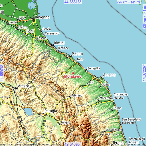
| \ | Map #1 | Topo.Map |
| Scale [m] | 78..319 m | × |
| Scale [ft] | 256..1047 ft | × |
| Average | 166.4 m = 546 ft | × |
| Width | 7.07 km = 4.4 mi | 226.2 km = 140.6 mi |
| Height | 7.07 km = 4.4 mi | 226.2 km = 140.6 mi |
| ↑Max Latitude | 43.706456° | 44.68316° |
| Latitude at center | 43.67468° | 43.67468° |
| ↓Min Latitude | 43.642887° | 42.64896° |
| ← Min Longitude | 12.922065° | 11.55976° |
| Longitude center | 12.96601° | 12.96601° |
| →Max Longitude | 13.009955° | 14.37226° |
Nearby cities:
Cities around Mondavio sort by population:
• San Lorenzo in Campo elevation 174 m
8.3 km,  192°
192°
• Villanova 73 m
7.6 km,  341°
341°
• Orciano di Pesaro 234 m
1.7 km,  16°
16°
• San Michele 104 m
2.9 km,  118°
118°
• Monte Porzio 100 m
6.8 km,  74°
74°
• Castelleone di Suasa 201 m
7.5 km,  172°
172°
• San Giorgio di Pesaro 186 m
5.4 km,  11°
11°
• Piagge 184 m
6.6 km,  1°
1°
• Barchi 319 m
3 km,  266°
266°
• Fratte Rosa 403 m
6.9 km,  228°
228°
• Sant'Ippolito 256 m
7.3 km, 274°
• Montemaggiore al Metauro 162 m
7.1 km,  346°
346°
Multilingual:
 En español:
Mondavio elevación 248 m.
 En France:
Mondavio élévation 248 m.
 Auf Deutsch:
Mondavio höhe über dem Meeresspiegel ist 248 m.

Sources and notes:
- [note 1] Map square and city borders are not equal. Map elevation data is calculated only from area inside that square.
- [src 1] Elevation data from geonames database provided with same terms of usage.
- [src 2] The elevation map of Mondavio is generated using elevation data from NASA's 3 arcsec (90m) resolution SRTM data.
- [src 3] Base (background) map © OpenStreetMap contributors tiles are generated by Geofabrik and OpenTopoMap.
Copyright & License:
This Mondavio Elevation Map is licensed under CC BY-SA. You may reuse any part from this page, if you give a proper credit by linking to this URL:
 More info on terms of use page.