Montebello elevation
Montebello (Lombardy, Provincia di Pavia), Italy elevation is 121 meters and Montebello elevation in feet is 397 ft above sea level [src 1]. Montebello is a seat of a third-order administrative division (feature code) with elevation that is 201 meters (659 ft) smaller than average city elevation in Italy.
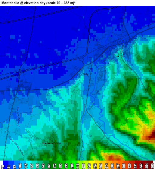
Below is the Elevation map of Montebello, which displays elevation range with different colors. Scale of the first map is from 70 to 365 m (230 to 1198 ft) with average elevation of 115.6 meters (=379 ft) [note 1]
These maps also provides idea of topography and contour of this city, they are displayed at different zoom levels. More info about maps, scale and edge coordinates you can find below images.
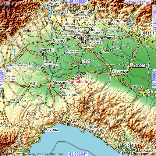
| \ | Map #1 | Topo.Map |
| Scale [m] | 70..365 m | × |
| Scale [ft] | 230..1198 ft | × |
| Average | 115.6 m = 379 ft | × |
| Width | 6.91 km = 4.3 mi | 221.1 km = 137.4 mi |
| Height | 6.91 km = 4.3 mi | 221.1 km = 137.4 mi |
| ↑Max Latitude | 45.031006° | 45.98568° |
| Latitude at center | 44.99994° | 44.99994° |
| ↓Min Latitude | 44.968858° | 43.99694° |
| ← Min Longitude | 9.058685° | 7.69638° |
| Longitude center | 9.10263° | 9.10263° |
| →Max Longitude | 9.146575° | 10.50888° |
Nearby cities:
Cities around Montebello sort by population:
• Casteggio elevation 95 m
2.4 km,  48°
48°
• Lungavilla 71 m
5 km,  337°
337°
• Corvino San Quirico 204 m
4.9 km,  75°
75°
• Torrazza Coste 120 m
3.2 km,  220°
220°
• Codevilla 149 m
5.4 km, 221°
• Casatisma 73 m
5.6 km,  23°
23°
• Torricella Verzate 101 m
6 km,  68°
68°
• Verretto 76 m
4.5 km,  10°
10°
• San Rocco 203 m
4.8 km, 77°
• Borgo Priolo 140 m
5.2 km,  136°
136°
• Calvignano 267 m
5.5 km,  109°
109°
• Oliva Gessi 242 m
5.6 km, 83°
Multilingual:
 En español:
Montebello elevación 121 m.
 En France:
Montebello della Battaglia élévation 121 m.
 Auf Deutsch:
Montebello della Battaglia höhe über dem Meeresspiegel ist 121 m.

Sources and notes:
- [note 1] Map square and city borders are not equal. Map elevation data is calculated only from area inside that square.
- [src 1] Elevation data from geonames database provided with same terms of usage.
- [src 2] The elevation map of Montebello is generated using elevation data from NASA's 3 arcsec (90m) resolution SRTM data.
- [src 3] Base (background) map © OpenStreetMap contributors tiles are generated by Geofabrik and OpenTopoMap.
Copyright & License:
This Montebello Elevation Map is licensed under CC BY-SA. You may reuse any part from this page, if you give a proper credit by linking to this URL:
 More info on terms of use page.