Montecassiano elevation
Montecassiano (The Marches, Provincia di Macerata), Italy elevation is 187 meters and Montecassiano elevation in feet is 614 ft above sea level [src 1]. Montecassiano is a seat of a third-order administrative division (feature code) with elevation that is 135 meters (443 ft) smaller than average city elevation in Italy.
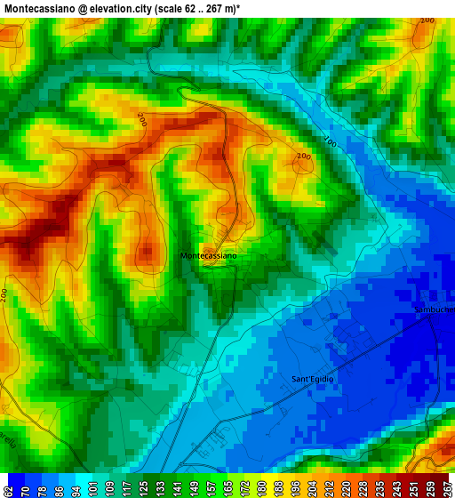
Below is the Elevation map of Montecassiano, which displays elevation range with different colors. Scale of the first map is from 62 to 267 m (203 to 876 ft) with average elevation of 137.3 meters (=450 ft) [note 1]
These maps also provides idea of topography and contour of this city, they are displayed at different zoom levels. More info about maps, scale and edge coordinates you can find below images.
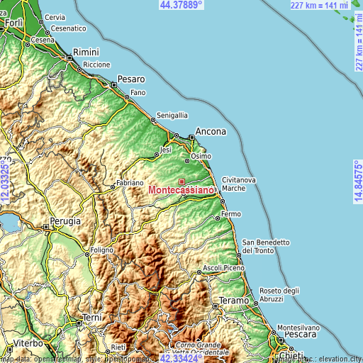
| \ | Map #1 | Topo.Map |
| Scale [m] | 62..267 m | × |
| Scale [ft] | 203..876 ft | × |
| Average | 137.3 m = 450 ft | × |
| Width | 7.1 km = 4.4 mi | 227.3 km = 141.2 mi |
| Height | 7.1 km = 4.4 mi | 227.3 km = 141.2 mi |
| ↑Max Latitude | 43.397119° | 44.37889° |
| Latitude at center | 43.36518° | 43.36518° |
| ↓Min Latitude | 43.333224° | 42.33424° |
| ← Min Longitude | 13.395555° | 12.03325° |
| Longitude center | 13.4395° | 13.4395° |
| →Max Longitude | 13.483445° | 14.84575° |
Nearby cities:
Cities around Montecassiano sort by population:
• Macerata elevation 276 m
7.6 km,  171°
171°
• Recanati 236 m
10.2 km,  65°
65°
• Filottrano 275 m
10.6 km,  317°
317°
• Appignano 198 m
7.4 km,  267°
267°
• Piediripa 92 m
10.5 km,  158°
158°
• Montefano 210 m
5 km,  357°
357°
• Sforzacosta 133 m
12.1 km,  186°
186°
• Villa Potenza 94 m
5 km, 192°
• Montelupone 253 m
10.9 km,  103°
103°
• Campocavallo 47 m
11.6 km,  23°
23°
• Zona Industriale 107 m
12.2 km, 161°
• Padiglione 59 m
11.7 km,  9°
9°
Multilingual:
 En español:
Montecassiano elevación 187 m.
 En France:
Montecassiano élévation 187 m.
 Auf Deutsch:
Montecassiano höhe über dem Meeresspiegel ist 187 m.

Sources and notes:
- [note 1] Map square and city borders are not equal. Map elevation data is calculated only from area inside that square.
- [src 1] Elevation data from geonames database provided with same terms of usage.
- [src 2] The elevation map of Montecassiano is generated using elevation data from NASA's 3 arcsec (90m) resolution SRTM data.
- [src 3] Base (background) map © OpenStreetMap contributors tiles are generated by Geofabrik and OpenTopoMap.
Copyright & License:
This Montecassiano Elevation Map is licensed under CC BY-SA. You may reuse any part from this page, if you give a proper credit by linking to this URL:
 More info on terms of use page.