Montecelio elevation
Montecelio (Latium, Città metropolitana di Roma Capitale), Italy elevation is 327 meters and Montecelio elevation in feet is 1073 ft above sea level [src 1]. Montecelio is a populated place (feature code) with elevation that is 5 meters (16 ft) bigger than average city elevation in Italy.
Below is the Elevation map of Montecelio, which displays elevation range with different colors. Scale of the first map is from 73 to 417 m (240 to 1368 ft) with average elevation of 172.4 meters (=566 ft) [note 1]
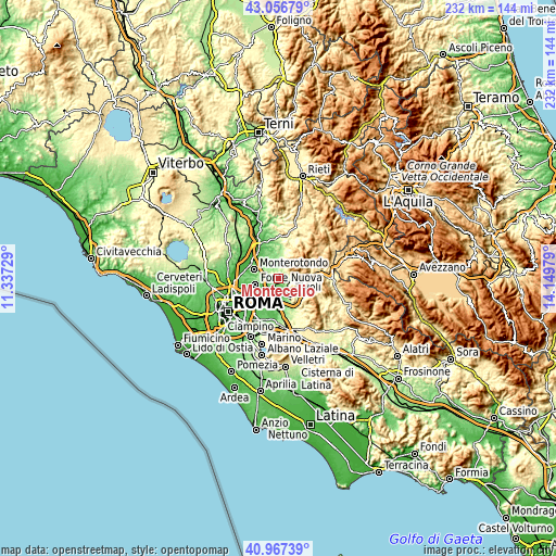
These maps also provides idea of topography and contour of this city, they are displayed at different zoom levels. More info about maps, scale and edge coordinates you can find below images.
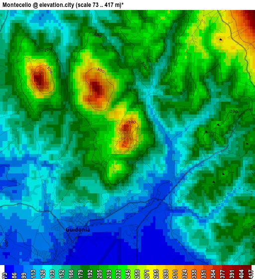
| \ | Map #1 | Topo.Map |
| Scale [m] | 73..417 m | × |
| Scale [ft] | 240..1368 ft | × |
| Average | 172.4 m = 566 ft | × |
| Width | 7.26 km = 4.5 mi | 232.3 km = 144.3 mi |
| Height | 7.26 km = 4.5 mi | 232.3 km = 144.3 mi |
| ↑Max Latitude | 42.053309° | 43.05679° |
| Latitude at center | 42.02067° | 42.02067° |
| ↓Min Latitude | 41.988014° | 40.96739° |
| ← Min Longitude | 12.699595° | 11.33729° |
| Longitude center | 12.74354° | 12.74354° |
| →Max Longitude | 12.787485° | 14.14979° |
Nearby cities:
Cities around Montecelio sort by population:
• Guidonia Montecelio elevation 92 m
3.5 km,  210°
210°
• Guidonia 95 m
3.8 km, 213°
• Villanova 68 m
6.4 km,  170°
170°
• Villa Adriana 66 m
7.7 km,  162°
162°
• Villalba 72 m
7.5 km,  188°
188°
• Marcellina 285 m
5 km,  85°
85°
• Palombara Sabina 297 m
5.7 km,  19°
19°
• Campo Limpido-Favale 71 m
6.3 km, 159°
• Sant'Angelo Romano 381 m
3 km,  303°
303°
• Castel Chiodato 171 m
5.5 km,  316°
316°
• La Botte 76 m
4.8 km, 155°
• Cretone 150 m
6.5 km,  329°
329°
Multilingual:
 En español:
Montecelio elevación 327 m.
 En France:
Montecelio élévation 327 m.
 Auf Deutsch:
Montecelio höhe über dem Meeresspiegel ist 327 m.

Sources and notes:
- [note 1] Map square and city borders are not equal. Map elevation data is calculated only from area inside that square.
- [src 1] Elevation data from geonames database provided with same terms of usage.
- [src 2] The elevation map of Montecelio is generated using elevation data from NASA's 3 arcsec (90m) resolution SRTM data.
- [src 3] Base (background) map © OpenStreetMap contributors tiles are generated by Geofabrik and OpenTopoMap.
Copyright & License:
This Montecelio Elevation Map is licensed under CC BY-SA. You may reuse any part from this page, if you give a proper credit by linking to this URL:
 More info on terms of use page.