Montecorice elevation
Montecorice (Campania, Provincia di Salerno), Italy elevation is 94 meters and Montecorice elevation in feet is 308 ft above sea level [src 1]. Montecorice is a seat of a third-order administrative division (feature code) with elevation that is 228 meters (748 ft) smaller than average city elevation in Italy.
Below is the Elevation map of Montecorice, which displays elevation range with different colors. Scale of the first map is from 0 to 769 m (0 to 2523 ft) with average elevation of 191.8 meters (=629 ft) [note 1]
These maps also provides idea of topography and contour of this city, they are displayed at different zoom levels. More info about maps, scale and edge coordinates you can find below images.
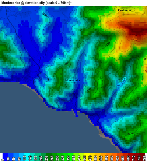
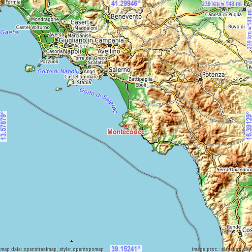
| \ | Map #1 | Topo.Map |
| Scale [m] | 0..769 m | × |
| Scale [ft] | 0..2523 ft | × |
| Average | 191.8 m = 629 ft | × |
| Width | 7.46 km = 4.6 mi | 238.7 km = 148.3 mi |
| Height | 7.46 km = 4.6 mi | 238.7 km = 148.3 mi |
| ↑Max Latitude | 40.26798° | 41.29946° |
| Latitude at center | 40.23444° | 40.23444° |
| ↓Min Latitude | 40.200883° | 39.15241° |
| ← Min Longitude | 14.941095° | 13.57879° |
| Longitude center | 14.98504° | 14.98504° |
| →Max Longitude | 15.028985° | 16.39129° |
Nearby cities:
Cities around Montecorice sort by population:
• Santa Maria elevation 23 m
7.6 km,  338°
338°
• San Marco 29 m
5.4 km,  313°
313°
• Rutino 334 m
10.5 km,  45°
45°
• Omignano 543 m
8.6 km,  78°
78°
• Perdifumo 432 m
4.5 km,  36°
36°
• San Mauro Cilento 562 m
5.2 km,  100°
100°
• Pollica 374 m
7.8 km,  128°
128°
• Sessa Cilento 521 m
8.2 km,  70°
70°
• Stella Cilento 394 m
9.2 km,  91°
91°
• Lustra 469 m
9.3 km, 49°
• Serramezzana 517 m
4.2 km, 74°
• Laureana Cilento 405 m
8.7 km,  31°
31°
Multilingual:
 En español:
Montecorice elevación 94 m.
 En France:
Montecorice élévation 94 m.
 Auf Deutsch:
Montecorice höhe über dem Meeresspiegel ist 94 m.

Sources and notes:
- [note 1] Map square and city borders are not equal. Map elevation data is calculated only from area inside that square.
- [src 1] Elevation data from geonames database provided with same terms of usage.
- [src 2] The elevation map of Montecorice is generated using elevation data from NASA's 3 arcsec (90m) resolution SRTM data.
- [src 3] Base (background) map © OpenStreetMap contributors tiles are generated by Geofabrik and OpenTopoMap.
Copyright & License:
This Montecorice Elevation Map is licensed under CC BY-SA. You may reuse any part from this page, if you give a proper credit by linking to this URL:
 More info on terms of use page.