Montecosaro elevation
Montecosaro (The Marches, Provincia di Macerata), Italy elevation is 218 meters and Montecosaro elevation in feet is 715 ft above sea level [src 1]. Montecosaro is a seat of a third-order administrative division (feature code) with elevation that is 104 meters (341 ft) smaller than average city elevation in Italy.
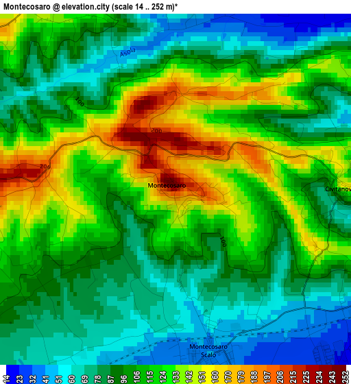
Below is the Elevation map of Montecosaro, which displays elevation range with different colors. Scale of the first map is from 14 to 252 m (46 to 827 ft) with average elevation of 104.6 meters (=343 ft) [note 1]
These maps also provides idea of topography and contour of this city, they are displayed at different zoom levels. More info about maps, scale and edge coordinates you can find below images.
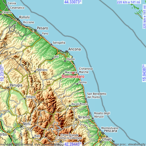
| \ | Map #1 | Topo.Map |
| Scale [m] | 14..252 m | × |
| Scale [ft] | 46..827 ft | × |
| Average | 104.6 m = 343 ft | × |
| Width | 7.11 km = 4.4 mi | 227.5 km = 141.4 mi |
| Height | 7.11 km = 4.4 mi | 227.5 km = 141.4 mi |
| ↑Max Latitude | 43.348155° | 44.33073° |
| Latitude at center | 43.31619° | 43.31619° |
| ↓Min Latitude | 43.284208° | 42.28443° |
| ← Min Longitude | 13.593675° | 12.23137° |
| Longitude center | 13.63762° | 13.63762° |
| →Max Longitude | 13.681565° | 15.04387° |
Nearby cities:
Cities around Montecosaro sort by population:
• Civitanova Marche elevation 16 m
6.8 km,  100°
100°
• Porto Potenza Picena 6 m
6.7 km,  46°
46°
• Trodica 55 m
5.8 km,  217°
217°
• Potenza Picena 225 m
5.7 km,  347°
347°
• Borgo Stazione 40 m
3.6 km,  171°
171°
• Casette d'Ete 34 m
7.9 km,  151°
151°
• Santa Maria Apparente 34 m
4.9 km,  116°
116°
• Civitanova Alta 152 m
3.4 km,  90°
90°
• Montelupone 253 m
6.2 km,  298°
298°
• Morrovalle 227 m
3.4 km,  273°
273°
• Cascinare 127 m
8.3 km,  133°
133°
• Villa San Filippo 55 m
7.2 km,  209°
209°
Multilingual:
 En español:
Montecosaro elevación 218 m.
 En France:
Montecosaro élévation 218 m.
 Auf Deutsch:
Montecosaro höhe über dem Meeresspiegel ist 218 m.

Sources and notes:
- [note 1] Map square and city borders are not equal. Map elevation data is calculated only from area inside that square.
- [src 1] Elevation data from geonames database provided with same terms of usage.
- [src 2] The elevation map of Montecosaro is generated using elevation data from NASA's 3 arcsec (90m) resolution SRTM data.
- [src 3] Base (background) map © OpenStreetMap contributors tiles are generated by Geofabrik and OpenTopoMap.
Copyright & License:
This Montecosaro Elevation Map is licensed under CC BY-SA. You may reuse any part from this page, if you give a proper credit by linking to this URL:
 More info on terms of use page.