Montefusco elevation
Montefusco (Campania, Provincia di Avellino), Italy elevation is 694 meters and Montefusco elevation in feet is 2277 ft above sea level [src 1]. Montefusco is a seat of a third-order administrative division (feature code) with elevation that is 372 meters (1220 ft) bigger than average city elevation in Italy.
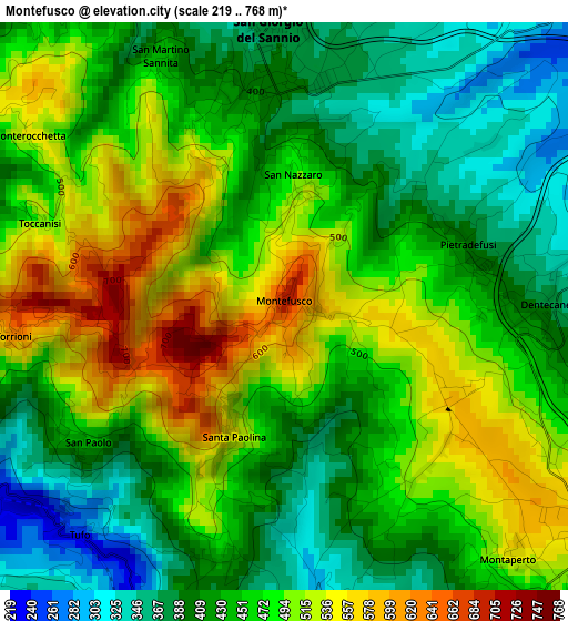
Below is the Elevation map of Montefusco, which displays elevation range with different colors. Scale of the first map is from 219 to 768 m (719 to 2520 ft) with average elevation of 458.9 meters (=1506 ft) [note 1]
These maps also provides idea of topography and contour of this city, they are displayed at different zoom levels. More info about maps, scale and edge coordinates you can find below images.
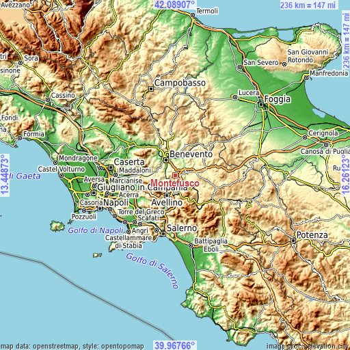
| \ | Map #1 | Topo.Map |
| Scale [m] | 219..768 m | × |
| Scale [ft] | 719..2520 ft | × |
| Average | 458.9 m = 1506 ft | × |
| Width | 7.37 km = 4.6 mi | 235.9 km = 146.6 mi |
| Height | 7.37 km = 4.6 mi | 235.9 km = 146.6 mi |
| ↑Max Latitude | 41.070049° | 42.08907° |
| Latitude at center | 41.03691° | 41.03691° |
| ↓Min Latitude | 41.003754° | 39.96766° |
| ← Min Longitude | 14.811035° | 13.44873° |
| Longitude center | 14.85498° | 14.85498° |
| →Max Longitude | 14.898925° | 16.26123° |
Nearby cities:
Cities around Montefusco sort by population:
• San Giorgio del Sannio elevation 383 m
3.5 km,  357°
357°
• Montemiletto 570 m
4.7 km,  126°
126°
• Pietradefusi 384 m
2.5 km,  74°
74°
• Calvi 364 m
4 km,  12°
12°
• San Nazzaro 485 m
1.7 km, 6°
• Sant'Elena Irpina 407 m
2.9 km,  88°
88°
• Tufo 224 m
4.1 km,  229°
229°
• Santa Paolina 539 m
1.8 km,  203°
203°
• Torre le Nocelle 429 m
4.8 km,  108°
108°
• San Martino Sannita 444 m
3.6 km,  332°
332°
• Torrioni 663 m
3.5 km,  264°
264°
• Petruro Irpino 491 m
4.8 km, 263°
Multilingual:
 En español:
Montefusco elevación 694 m.
 En France:
Montefusco élévation 694 m.
 Auf Deutsch:
Montefusco höhe über dem Meeresspiegel ist 694 m.

Sources and notes:
- [note 1] Map square and city borders are not equal. Map elevation data is calculated only from area inside that square.
- [src 1] Elevation data from geonames database provided with same terms of usage.
- [src 2] The elevation map of Montefusco is generated using elevation data from NASA's 3 arcsec (90m) resolution SRTM data.
- [src 3] Base (background) map © OpenStreetMap contributors tiles are generated by Geofabrik and OpenTopoMap.
Copyright & License:
This Montefusco Elevation Map is licensed under CC BY-SA. You may reuse any part from this page, if you give a proper credit by linking to this URL:
 More info on terms of use page.