Montelabbate elevation
Montelabbate (The Marches, Provincia di Pesaro e Urbino), Italy elevation is 58 meters and Montelabbate elevation in feet is 190 ft above sea level [src 1]. Montelabbate is a seat of a third-order administrative division (feature code) with elevation that is 264 meters (866 ft) smaller than average city elevation in Italy.
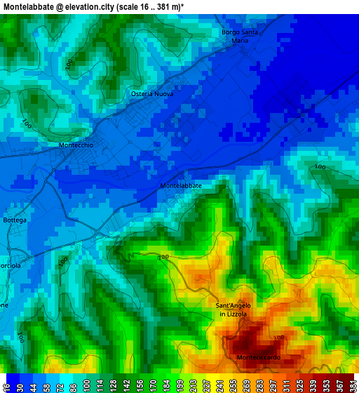
Below is the Elevation map of Montelabbate, which displays elevation range with different colors. Scale of the first map is from 16 to 381 m (52 to 1250 ft) with average elevation of 110.1 meters (=361 ft) [note 1]
These maps also provides idea of topography and contour of this city, they are displayed at different zoom levels. More info about maps, scale and edge coordinates you can find below images.
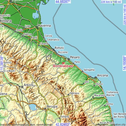
| \ | Map #1 | Topo.Map |
| Scale [m] | 16..381 m | × |
| Scale [ft] | 52..1250 ft | × |
| Average | 110.1 m = 361 ft | × |
| Width | 7.05 km = 4.4 mi | 225.5 km = 140.1 mi |
| Height | 7.05 km = 4.4 mi | 225.5 km = 140.1 mi |
| ↑Max Latitude | 43.879004° | 44.85287° |
| Latitude at center | 43.84732° | 43.84732° |
| ↓Min Latitude | 43.815619° | 42.82453° |
| ← Min Longitude | 12.743685° | 11.38138° |
| Longitude center | 12.78763° | 12.78763° |
| →Max Longitude | 12.831575° | 14.19388° |
Nearby cities:
Cities around Montelabbate sort by population:
• Borgo Santa Maria elevation 38 m
3.4 km,  20°
20°
• Cappone 75 m
3.9 km,  241°
241°
• Tavullia 152 m
6.3 km,  332°
332°
• Villa Ceccolini 44 m
4.3 km,  63°
63°
• Bottega 59 m
3 km,  265°
265°
• Padiglione 60 m
5.3 km,  275°
275°
• Rio Salso-Case Bernardi 82 m
7.9 km,  259°
259°
• Monteciccardo 321 m
2.9 km,  153°
153°
• Sant'Angelo in Lizzola 288 m
2.5 km,  155°
155°
• Mombaroccio 304 m
7.9 km,  137°
137°
• Colbordolo 299 m
6.1 km, 240°
• Montegridolfo 269 m
7.9 km, 278°
Multilingual:
 En español:
Montelabbate elevación 58 m.
 En France:
Montelabbate élévation 58 m.
 Auf Deutsch:
Montelabbate höhe über dem Meeresspiegel ist 58 m.

Sources and notes:
- [note 1] Map square and city borders are not equal. Map elevation data is calculated only from area inside that square.
- [src 1] Elevation data from geonames database provided with same terms of usage.
- [src 2] The elevation map of Montelabbate is generated using elevation data from NASA's 3 arcsec (90m) resolution SRTM data.
- [src 3] Base (background) map © OpenStreetMap contributors tiles are generated by Geofabrik and OpenTopoMap.
Copyright & License:
This Montelabbate Elevation Map is licensed under CC BY-SA. You may reuse any part from this page, if you give a proper credit by linking to this URL:
 More info on terms of use page.