Montemonaco elevation
Montemonaco (The Marches, Provincia di Ascoli Piceno), Italy elevation is 949 meters and Montemonaco elevation in feet is 3114 ft above sea level [src 1]. Montemonaco is a seat of a third-order administrative division (feature code) with elevation that is 627 meters (2057 ft) bigger than average city elevation in Italy.
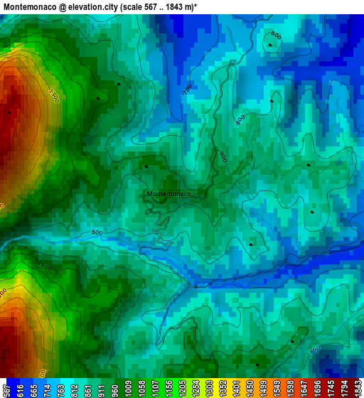
Below is the Elevation map of Montemonaco, which displays elevation range with different colors. Scale of the first map is from 567 to 1843 m (1860 to 6047 ft) with average elevation of 903.9 meters (=2966 ft) [note 1]
These maps also provides idea of topography and contour of this city, they are displayed at different zoom levels. More info about maps, scale and edge coordinates you can find below images.
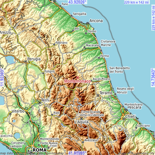
| \ | Map #1 | Topo.Map |
| Scale [m] | 567..1843 m | × |
| Scale [ft] | 1860..6047 ft | × |
| Average | 903.9 m = 2966 ft | × |
| Width | 7.16 km = 4.4 mi | 229.1 km = 142.4 mi |
| Height | 7.16 km = 4.4 mi | 229.1 km = 142.4 mi |
| ↑Max Latitude | 42.930894° | 43.92026° |
| Latitude at center | 42.89871° | 42.89871° |
| ↓Min Latitude | 42.866509° | 41.85995° |
| ← Min Longitude | 13.286235° | 11.92393° |
| Longitude center | 13.33018° | 13.33018° |
| →Max Longitude | 13.374125° | 14.73643° |
Nearby cities:
Cities around Montemonaco sort by population:
• Comunanza elevation 453 m
9.4 km,  46°
46°
• Amandola 478 m
9.1 km,  12°
12°
• Venarotta 426 m
13.3 km,  97°
97°
• Marsia 297 m
12.6 km,  109°
109°
• Force 662 m
14.6 km,  61°
61°
• Montefalcone Appennino 766 m
14.5 km, 45°
• Montefortino 601 m
5.1 km, 12°
• Castelsantangelo sul Nera 735 m
14.3 km,  267°
267°
• Bolognola 1038 m
13.5 km,  321°
321°
• Balzo 872 m
6.3 km,  178°
178°
• Arquata del Tronto 708 m
14.4 km,  191°
191°
• Palmiano 534 m
10.5 km,  89°
89°
Multilingual:
 En español:
Montemonaco elevación 949 m.
 En France:
Montemonaco élévation 949 m.
 Auf Deutsch:
Montemonaco höhe über dem Meeresspiegel ist 949 m.

Sources and notes:
- [note 1] Map square and city borders are not equal. Map elevation data is calculated only from area inside that square.
- [src 1] Elevation data from geonames database provided with same terms of usage.
- [src 2] The elevation map of Montemonaco is generated using elevation data from NASA's 3 arcsec (90m) resolution SRTM data.
- [src 3] Base (background) map © OpenStreetMap contributors tiles are generated by Geofabrik and OpenTopoMap.
Copyright & License:
This Montemonaco Elevation Map is licensed under CC BY-SA. You may reuse any part from this page, if you give a proper credit by linking to this URL:
 More info on terms of use page.