Monteparano elevation
Monteparano (Apulia, Provincia di Taranto), Italy elevation is 129 meters and Monteparano elevation in feet is 423 ft above sea level [src 1]. Monteparano is a seat of a third-order administrative division (feature code) with elevation that is 193 meters (633 ft) smaller than average city elevation in Italy.
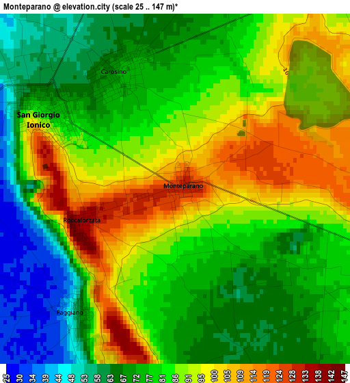
Below is the Elevation map of Monteparano, which displays elevation range with different colors. Scale of the first map is from 25 to 147 m (82 to 482 ft) with average elevation of 82.6 meters (=271 ft) [note 1]
These maps also provides idea of topography and contour of this city, they are displayed at different zoom levels. More info about maps, scale and edge coordinates you can find below images.
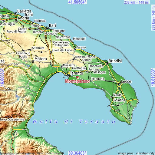
| \ | Map #1 | Topo.Map |
| Scale [m] | 25..147 m | × |
| Scale [ft] | 82..482 ft | × |
| Average | 82.6 m = 271 ft | × |
| Width | 7.44 km = 4.6 mi | 238 km = 147.9 mi |
| Height | 7.44 km = 4.6 mi | 238 km = 147.9 mi |
| ↑Max Latitude | 40.476786° | 41.50504° |
| Latitude at center | 40.44335° | 40.44335° |
| ↓Min Latitude | 40.409897° | 39.36463° |
| ← Min Longitude | 17.369135° | 16.00683° |
| Longitude center | 17.41308° | 17.41308° |
| →Max Longitude | 17.457025° | 18.81933° |
Nearby cities:
Cities around Monteparano sort by population:
• Grottaglie elevation 140 m
10.6 km,  11°
11°
• San Giorgio Ionico 77 m
3.2 km,  300°
300°
• Lizzano 55 m
6.2 km,  153°
153°
• Pulsano 42 m
8.4 km,  214°
214°
• San Marzano di San Giuseppe 134 m
7.8 km,  80°
80°
• Carosino 72 m
2.7 km,  333°
333°
• Monteiasi 56 m
6.8 km,  337°
337°
• Fragagnano 101 m
5.5 km,  105°
105°
• Faggiano 58 m
3.7 km, 214°
• Leporano 45 m
9.5 km,  224°
224°
• Roccaforzata 136 m
2.1 km,  250°
250°
• Monti d'Arena-Bosco Caggione 11 m
10.6 km,  202°
202°
Multilingual:
 En español:
Monteparano elevación 129 m.
 En France:
Monteparano élévation 129 m.
 Auf Deutsch:
Monteparano höhe über dem Meeresspiegel ist 129 m.

Sources and notes:
- [note 1] Map square and city borders are not equal. Map elevation data is calculated only from area inside that square.
- [src 1] Elevation data from geonames database provided with same terms of usage.
- [src 2] The elevation map of Monteparano is generated using elevation data from NASA's 3 arcsec (90m) resolution SRTM data.
- [src 3] Base (background) map © OpenStreetMap contributors tiles are generated by Geofabrik and OpenTopoMap.
Copyright & License:
This Monteparano Elevation Map is licensed under CC BY-SA. You may reuse any part from this page, if you give a proper credit by linking to this URL:
 More info on terms of use page.