Monterchi elevation
Monterchi (Tuscany, Province of Arezzo), Italy elevation is 306 meters and Monterchi elevation in feet is 1004 ft above sea level [src 1]. Monterchi is a seat of a third-order administrative division (feature code) with elevation that is 16 meters (52 ft) smaller than average city elevation in Italy.
Below is the Elevation map of Monterchi, which displays elevation range with different colors. Scale of the first map is from 288 to 571 m (945 to 1873 ft) with average elevation of 350.9 meters (=1151 ft) [note 1]
These maps also provides idea of topography and contour of this city, they are displayed at different zoom levels. More info about maps, scale and edge coordinates you can find below images.
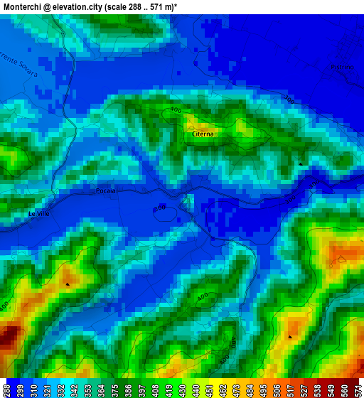
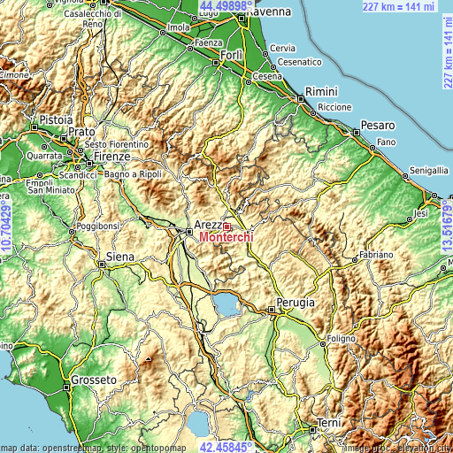
| \ | Map #1 | Topo.Map |
| Scale [m] | 288..571 m | × |
| Scale [ft] | 945..1873 ft | × |
| Average | 350.9 m = 1151 ft | × |
| Width | 7.09 km = 4.4 mi | 226.9 km = 141 mi |
| Height | 7.09 km = 4.4 mi | 226.9 km = 141 mi |
| ↑Max Latitude | 43.519205° | 44.49898° |
| Latitude at center | 43.48733° | 43.48733° |
| ↓Min Latitude | 43.455438° | 42.45845° |
| ← Min Longitude | 12.066595° | 10.70429° |
| Longitude center | 12.11054° | 12.11054° |
| →Max Longitude | 12.154485° | 13.51679° |
Nearby cities:
Cities around Monterchi sort by population:
• Città di Castello elevation 281 m
10.5 km,  103°
103°
• Sansepolcro 332 m
9.7 km,  13°
13°
• San Giustino 323 m
8.4 km,  38°
38°
• Selci-Lama 322 m
8.9 km,  68°
68°
• Pitigliano 362 m
14.9 km,  253°
253°
• Anghiari 399 m
7.3 km,  324°
324°
• Cerbara 298 m
8.2 km,  80°
80°
• Pistrino 292 m
4.2 km,  53°
53°
• San Secondo 267 m
13.6 km,  132°
132°
• Santa Fiora 312 m
8.1 km,  1°
1°
• Citerna 465 m
1.3 km, 11°
• Monte Santa Maria Tiberina 660 m
7 km,  143°
143°
Multilingual:
 En español:
Monterchi elevación 306 m.
 En France:
Monterchi élévation 306 m.
 Auf Deutsch:
Monterchi höhe über dem Meeresspiegel ist 306 m.

Sources and notes:
- [note 1] Map square and city borders are not equal. Map elevation data is calculated only from area inside that square.
- [src 1] Elevation data from geonames database provided with same terms of usage.
- [src 2] The elevation map of Monterchi is generated using elevation data from NASA's 3 arcsec (90m) resolution SRTM data.
- [src 3] Base (background) map © OpenStreetMap contributors tiles are generated by Geofabrik and OpenTopoMap.
Copyright & License:
This Monterchi Elevation Map is licensed under CC BY-SA. You may reuse any part from this page, if you give a proper credit by linking to this URL:
 More info on terms of use page.