Monterotondo elevation
Monterotondo (Latium, Città metropolitana di Roma Capitale), Italy elevation is 141 meters and Monterotondo elevation in feet is 463 ft above sea level [src 1]. Monterotondo is a seat of a third-order administrative division (feature code) with elevation that is 181 meters (594 ft) smaller than average city elevation in Italy.
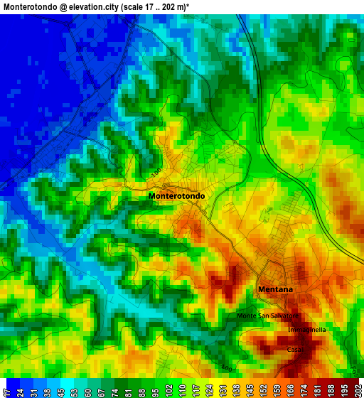
Below is the Elevation map of Monterotondo, which displays elevation range with different colors. Scale of the first map is from 17 to 202 m (56 to 663 ft) with average elevation of 92.3 meters (=303 ft) [note 1]
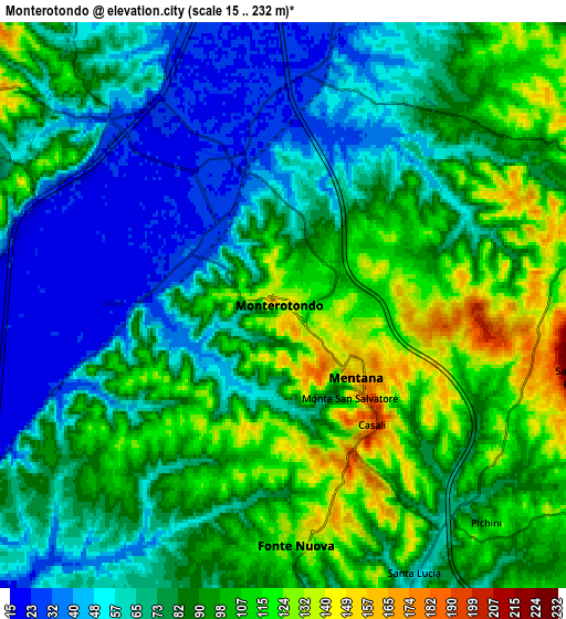
These maps also provides idea of topography and contour of this city, they are displayed at different zoom levels. More info about maps, scale and edge coordinates you can find below images.
| \ | Map #1 | Map #2 | Topo.Map |
| Scale [m] | 17..202 m | 15..232 m | × |
| Scale [ft] | 56..663 ft | 49..761 ft | × |
| Average | 92.3 m = 303 ft | 82.8 m = 272 ft | × |
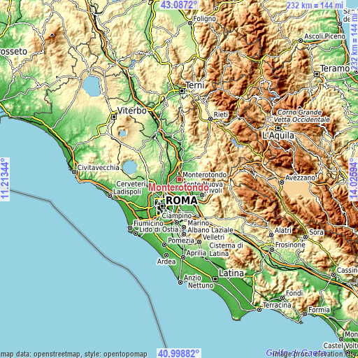
| Width | 7.26 km = 4.5 mi | 14.51 km = 9 mi | 232.2 km = 144.3 mi |
| Height | 7.26 km = 4.5 mi | 14.51 km = 9 mi | 232.2 km = 144.3 mi |
| ↑Max Latitude | 42.084213° | 42.116819° | 43.0872° |
| Latitude at center | 42.05159° | 42.05159° | 42.05159° |
| ↓Min Latitude | 42.01895° | 41.986294° | 40.99882° |
| ← Min Longitude | 12.575745° | 12.531799° | 11.21344° |
| Longitude center | 12.61969° | 12.61969° | 12.61969° |
| →Max Longitude | 12.663635° | 12.707581° | 14.02594° |
Nearby cities:
Cities around Monterotondo sort by population:
• Tor Lupara elevation 125 m
6 km,  181°
181°
• Mentana 157 m
2.7 km,  131°
131°
• Santa Lucia 60 m
8.3 km,  158°
158°
• Colle Verde 87 m
8.3 km, 180°
• Colleverde II 90 m
8.5 km,  173°
173°
• Laghetto 94 m
9.8 km, 162°
• Sant'Angelo Romano 381 m
7.9 km,  102°
102°
• Bivio di Capanelle 31 m
7.9 km,  344°
344°
• Castel Chiodato 171 m
6.5 km,  85°
85°
• Girardi-Bellavista-Terrazze 57 m
6.6 km,  329°
329°
• Costaroni 131 m
7.4 km,  293°
293°
• Cretone 150 m
7.3 km,  72°
72°
Multilingual:
 En español:
Monterotondo elevación 141 m.
 En France:
Monterotondo élévation 141 m.
 Auf Deutsch:
Monterotondo höhe über dem Meeresspiegel ist 141 m.

Sources and notes:
- [note 1] Map square and city borders are not equal. Map elevation data is calculated only from area inside that square.
- [src 1] Elevation data from geonames database provided with same terms of usage.
- [src 2] The elevation map of Monterotondo is generated using elevation data from NASA's 3 arcsec (90m) resolution SRTM data.
- [src 3] Base (background) map © OpenStreetMap contributors tiles are generated by Geofabrik and OpenTopoMap.
Copyright & License:
This Monterotondo Elevation Map is licensed under CC BY-SA. You may reuse any part from this page, if you give a proper credit by linking to this URL:
 More info on terms of use page.