Montieri elevation
Montieri (Tuscany, Provincia di Grosseto), Italy elevation is 683 meters and Montieri elevation in feet is 2241 ft above sea level [src 1]. Montieri is a seat of a third-order administrative division (feature code) with elevation that is 361 meters (1184 ft) bigger than average city elevation in Italy.
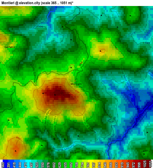
Below is the Elevation map of Montieri, which displays elevation range with different colors. Scale of the first map is from 365 to 1051 m (1198 to 3448 ft) with average elevation of 617.2 meters (=2025 ft) [note 1]
These maps also provides idea of topography and contour of this city, they are displayed at different zoom levels. More info about maps, scale and edge coordinates you can find below images.
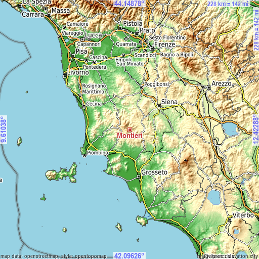
| \ | Map #1 | Topo.Map |
| Scale [m] | 365..1051 m | × |
| Scale [ft] | 1198..3448 ft | × |
| Average | 617.2 m = 2025 ft | × |
| Width | 7.13 km = 4.4 mi | 228.2 km = 141.8 mi |
| Height | 7.13 km = 4.4 mi | 228.2 km = 141.8 mi |
| ↑Max Latitude | 43.163192° | 44.14878° |
| Latitude at center | 43.13113° | 43.13113° |
| ↓Min Latitude | 43.099051° | 42.09626° |
| ← Min Longitude | 10.972685° | 9.61038° |
| Longitude center | 11.01663° | 11.01663° |
| →Max Longitude | 11.060575° | 12.42288° |
Nearby cities:
Cities around Montieri sort by population:
• Massa Marittima elevation 403 m
13.7 km,  227°
227°
• Pomarance 354 m
21.7 km,  327°
327°
• Rosia 206 m
21 km,  52°
52°
• Ribolla 60 m
17.9 km,  175°
175°
• Roccastrada 478 m
18.3 km,  137°
137°
• Castelnuovo di Val di Cecina 554 m
12.8 km,  314°
314°
• Sovicille 262 m
23.9 km, 45°
• Casole d'Elsa 374 m
23.5 km,  6°
6°
• Monterotondo Marittimo 536 m
13.1 km,  277°
277°
• Monticiano 364 m
13.1 km,  85°
85°
• Chiusdino 554 m
6 km,  64°
64°
• Radicondoli 492 m
14.6 km, 9°
Multilingual:
 En español:
Montieri elevación 683 m.
 En France:
Montieri élévation 683 m.
 Auf Deutsch:
Montieri höhe über dem Meeresspiegel ist 683 m.

Sources and notes:
- [note 1] Map square and city borders are not equal. Map elevation data is calculated only from area inside that square.
- [src 1] Elevation data from geonames database provided with same terms of usage.
- [src 2] The elevation map of Montieri is generated using elevation data from NASA's 3 arcsec (90m) resolution SRTM data.
- [src 3] Base (background) map © OpenStreetMap contributors tiles are generated by Geofabrik and OpenTopoMap.
Copyright & License:
This Montieri Elevation Map is licensed under CC BY-SA. You may reuse any part from this page, if you give a proper credit by linking to this URL:
 More info on terms of use page.