Montodine elevation
Montodine (Lombardy, Provincia di Cremona), Italy elevation is 57 meters and Montodine elevation in feet is 187 ft above sea level [src 1]. Montodine is a seat of a third-order administrative division (feature code) with elevation that is 265 meters (869 ft) smaller than average city elevation in Italy.
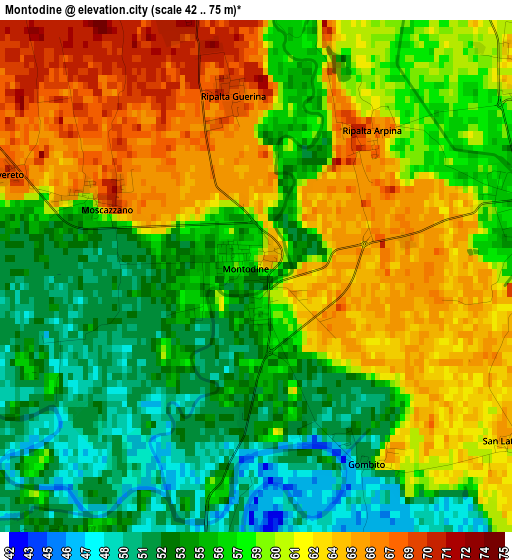
Below is the Elevation map of Montodine, which displays elevation range with different colors. Scale of the first map is from 42 to 75 m (138 to 246 ft) with average elevation of 58.4 meters (=192 ft) [note 1]
These maps also provides idea of topography and contour of this city, they are displayed at different zoom levels. More info about maps, scale and edge coordinates you can find below images.
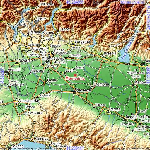
| \ | Map #1 | Topo.Map |
| Scale [m] | 42..75 m | × |
| Scale [ft] | 138..246 ft | × |
| Average | 58.4 m = 192 ft | × |
| Width | 6.88 km = 4.3 mi | 220 km = 136.7 mi |
| Height | 6.88 km = 4.3 mi | 220 km = 136.7 mi |
| ↑Max Latitude | 45.315101° | 46.26499° |
| Latitude at center | 45.28419° | 45.28419° |
| ↓Min Latitude | 45.253262° | 44.28614° |
| ← Min Longitude | 9.665155° | 8.30285° |
| Longitude center | 9.7091° | 9.7091° |
| →Max Longitude | 9.753045° | 11.11535° |
Nearby cities:
Cities around Montodine sort by population:
• Castelleone elevation 58 m
4.3 km,  72°
72°
• Castiglione d'Adda 61 m
7.6 km,  189°
189°
• Madignano 70 m
6.9 km,  8°
8°
• Ripalta Nuova 75 m
5.5 km,  346°
346°
• Capergnanica 77 m
7.9 km,  320°
320°
• Turano Lodigiano 64 m
7.9 km,  239°
239°
• Ripalta Arpina 67 m
2.5 km,  38°
38°
• Bertonico 64 m
6.5 km,  209°
209°
• Credera 70 m
4.7 km,  296°
296°
• Moscazzano 69 m
2.4 km, 295°
• Gombito 55 m
2.9 km,  148°
148°
• Ripalta Guerina 68 m
2.5 km, 350°
Multilingual:
 En español:
Montodine elevación 57 m.
 En France:
Montodine élévation 57 m.
 Auf Deutsch:
Montodine höhe über dem Meeresspiegel ist 57 m.

Sources and notes:
- [note 1] Map square and city borders are not equal. Map elevation data is calculated only from area inside that square.
- [src 1] Elevation data from geonames database provided with same terms of usage.
- [src 2] The elevation map of Montodine is generated using elevation data from NASA's 3 arcsec (90m) resolution SRTM data.
- [src 3] Base (background) map © OpenStreetMap contributors tiles are generated by Geofabrik and OpenTopoMap.
Copyright & License:
This Montodine Elevation Map is licensed under CC BY-SA. You may reuse any part from this page, if you give a proper credit by linking to this URL:
 More info on terms of use page.