Nimis elevation
Nimis (Friuli Venezia Giulia, Provincia di Udine), Italy elevation is 221 meters and Nimis elevation in feet is 725 ft above sea level [src 1]. Nimis is a seat of a third-order administrative division (feature code) with elevation that is 101 meters (331 ft) smaller than average city elevation in Italy.
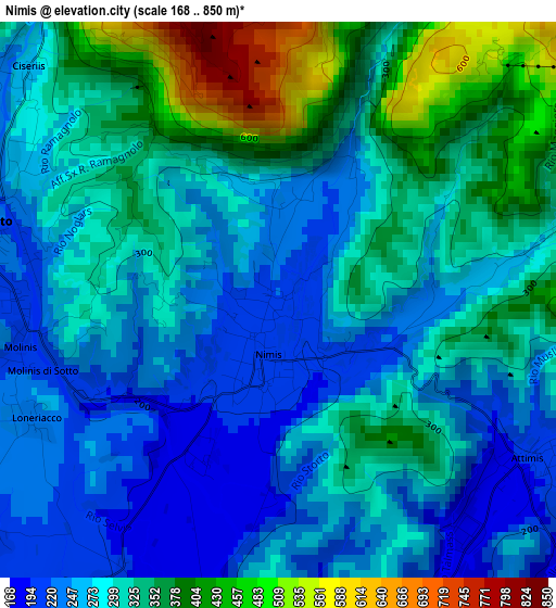
Below is the Elevation map of Nimis, which displays elevation range with different colors. Scale of the first map is from 168 to 850 m (551 to 2789 ft) with average elevation of 303.3 meters (=995 ft) [note 1]
These maps also provides idea of topography and contour of this city, they are displayed at different zoom levels. More info about maps, scale and edge coordinates you can find below images.
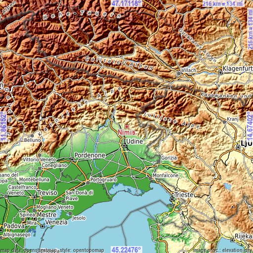
| \ | Map #1 | Topo.Map |
| Scale [m] | 168..850 m | × |
| Scale [ft] | 551..2789 ft | × |
| Average | 303.3 m = 995 ft | × |
| Width | 6.76 km = 4.2 mi | 216.4 km = 134.5 mi |
| Height | 6.76 km = 4.2 mi | 216.4 km = 134.5 mi |
| ↑Max Latitude | 46.236994° | 47.17118° |
| Latitude at center | 46.20659° | 46.20659° |
| ↓Min Latitude | 46.176169° | 45.22476° |
| ← Min Longitude | 13.223825° | 11.86152° |
| Longitude center | 13.26777° | 13.26777° |
| →Max Longitude | 13.311715° | 14.67402° |
Nearby cities:
Cities around Nimis sort by population:
• Tarcento elevation 221 m
4.1 km,  279°
279°
• Tricesimo 199 m
6.5 km,  218°
218°
• Reana del Rojale 154 m
7.2 km,  193°
193°
• Reana del Roiale 162 m
8.4 km,  204°
204°
• Cassacco 192 m
6.9 km,  237°
237°
• Magnano in Riviera 215 m
5.9 km,  288°
288°
• Faedis 159 m
8.7 km,  137°
137°
• Treppo Grande 217 m
8.8 km,  265°
265°
• Attimis 207 m
3.8 km,  118°
118°
• Taipana 484 m
7.4 km,  50°
50°
• Isola 451 m
8.7 km,  308°
308°
• Lusevera 484 m
7.6 km,  0°
0°
Multilingual:
 En español:
Nimis elevación 221 m.
 En France:
Nimis élévation 221 m.


Sources and notes:
- [note 1] Map square and city borders are not equal. Map elevation data is calculated only from area inside that square.
- [src 1] Elevation data from geonames database provided with same terms of usage.
- [src 2] The elevation map of Nimis is generated using elevation data from NASA's 3 arcsec (90m) resolution SRTM data.
- [src 3] Base (background) map © OpenStreetMap contributors tiles are generated by Geofabrik and OpenTopoMap.
Copyright & License:
This Nimis Elevation Map is licensed under CC BY-SA. You may reuse any part from this page, if you give a proper credit by linking to this URL:
 More info on terms of use page.