Nociglia elevation
Nociglia (Apulia, Provincia di Lecce), Italy elevation is 103 meters and Nociglia elevation in feet is 338 ft above sea level [src 1]. Nociglia is a seat of a third-order administrative division (feature code) with elevation that is 219 meters (719 ft) smaller than average city elevation in Italy.
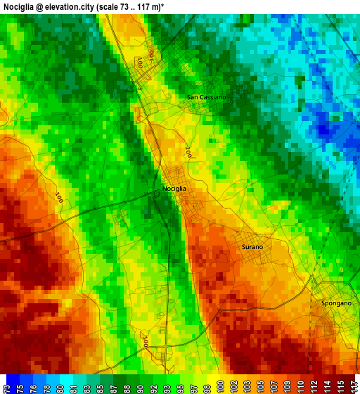
Below is the Elevation map of Nociglia, which displays elevation range with different colors. Scale of the first map is from 73 to 117 m (240 to 384 ft) with average elevation of 96 meters (=315 ft) [note 1]
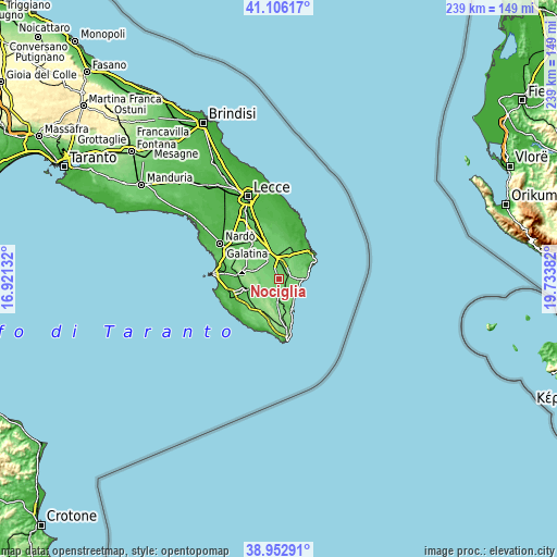
These maps also provides idea of topography and contour of this city, they are displayed at different zoom levels. More info about maps, scale and edge coordinates you can find below images.
| \ | Map #1 | Topo.Map |
| Scale [m] | 73..117 m | × |
| Scale [ft] | 240..384 ft | × |
| Average | 96 m = 315 ft | × |
| Width | 7.48 km = 4.6 mi | 239.4 km = 148.8 mi |
| Height | 7.48 km = 4.6 mi | 239.4 km = 148.8 mi |
| ↑Max Latitude | 40.071677° | 41.10617° |
| Latitude at center | 40.03804° | 40.03804° |
| ↓Min Latitude | 40.004386° | 38.95291° |
| ← Min Longitude | 18.283625° | 16.92132° |
| Longitude center | 18.32757° | 18.32757° |
| →Max Longitude | 18.371515° | 19.73382° |
Nearby cities:
Cities around Nociglia sort by population:
• Scorrano elevation 99 m
6.3 km,  337°
337°
• Poggiardo 87 m
4.6 km,  68°
68°
• Spongano 99 m
3.9 km,  124°
124°
• Botrugno 93 m
2.9 km,  351°
351°
• Montesano Salentino 105 m
7 km,  183°
183°
• San Cassiano 91 m
2.1 km,  14°
14°
• Surano 102 m
1.9 km,  125°
125°
• Sanarica 79 m
5.9 km,  17°
17°
• Giuggianello 80 m
7.1 km,  29°
29°
• Castiglione 116 m
6.4 km,  162°
162°
• Diso 98 m
6.3 km, 120°
• Ortelle 98 m
5.4 km,  95°
95°
Multilingual:
 En español:
Nociglia elevación 103 m.
 En France:
Nociglia élévation 103 m.
 Auf Deutsch:
Nociglia höhe über dem Meeresspiegel ist 103 m.

Sources and notes:
- [note 1] Map square and city borders are not equal. Map elevation data is calculated only from area inside that square.
- [src 1] Elevation data from geonames database provided with same terms of usage.
- [src 2] The elevation map of Nociglia is generated using elevation data from NASA's 3 arcsec (90m) resolution SRTM data.
- [src 3] Base (background) map © OpenStreetMap contributors tiles are generated by Geofabrik and OpenTopoMap.
Copyright & License:
This Nociglia Elevation Map is licensed under CC BY-SA. You may reuse any part from this page, if you give a proper credit by linking to this URL:
 More info on terms of use page.