Offlaga elevation
Offlaga (Lombardy, Provincia di Brescia), Italy elevation is 72 meters and Offlaga elevation in feet is 236 ft above sea level [src 1]. Offlaga is a seat of a third-order administrative division (feature code) with elevation that is 250 meters (820 ft) smaller than average city elevation in Italy.
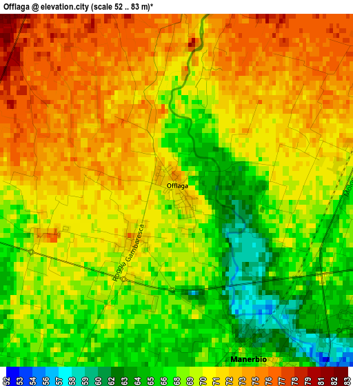
Below is the Elevation map of Offlaga, which displays elevation range with different colors. Scale of the first map is from 52 to 83 m (171 to 272 ft) with average elevation of 69.9 meters (=229 ft) [note 1]
These maps also provides idea of topography and contour of this city, they are displayed at different zoom levels. More info about maps, scale and edge coordinates you can find below images.
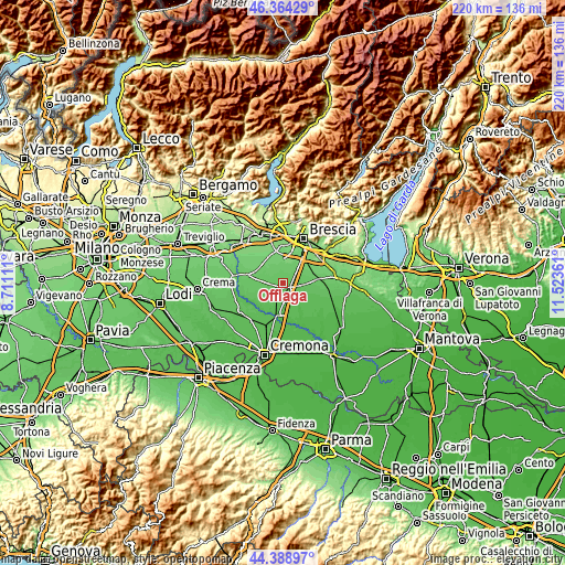
| \ | Map #1 | Topo.Map |
| Scale [m] | 52..83 m | × |
| Scale [ft] | 171..272 ft | × |
| Average | 69.9 m = 229 ft | × |
| Width | 6.86 km = 4.3 mi | 219.6 km = 136.5 mi |
| Height | 6.86 km = 4.3 mi | 219.6 km = 136.5 mi |
| ↑Max Latitude | 45.416116° | 46.36429° |
| Latitude at center | 45.38526° | 45.38526° |
| ↓Min Latitude | 45.354387° | 44.38897° |
| ← Min Longitude | 10.073415° | 8.71111° |
| Longitude center | 10.11736° | 10.11736° |
| →Max Longitude | 10.161305° | 11.52361° |
Nearby cities:
Cities around Offlaga sort by population:
• Manerbio elevation 69 m
3.8 km,  155°
155°
• Bagnolo Mella 86 m
7.2 km,  48°
48°
• Leno 65 m
8 km,  102°
102°
• Verolanuova 63 m
7 km,  205°
205°
• San Paolo 74 m
7.4 km,  258°
258°
• Verolavecchia 63 m
8 km,  217°
217°
• Dello 84 m
5 km,  319°
319°
• Azzano Mella 93 m
7.7 km,  359°
359°
• Bassano Bresciano 63 m
6.4 km,  172°
172°
• Mairano 94 m
7.6 km,  337°
337°
• Barbariga 80 m
5.4 km,  294°
294°
• Longhena 93 m
7.4 km, 322°
Multilingual:
 En español:
Offlaga elevación 72 m.
 En France:
Offlaga élévation 72 m.


Sources and notes:
- [note 1] Map square and city borders are not equal. Map elevation data is calculated only from area inside that square.
- [src 1] Elevation data from geonames database provided with same terms of usage.
- [src 2] The elevation map of Offlaga is generated using elevation data from NASA's 3 arcsec (90m) resolution SRTM data.
- [src 3] Base (background) map © OpenStreetMap contributors tiles are generated by Geofabrik and OpenTopoMap.
Copyright & License:
This Offlaga Elevation Map is licensed under CC BY-SA. You may reuse any part from this page, if you give a proper credit by linking to this URL:
 More info on terms of use page.