Olmedo elevation
Olmedo (Sardinia, Provincia di Sassari), Italy elevation is 57 meters and Olmedo elevation in feet is 187 ft above sea level [src 1]. Olmedo is a seat of a third-order administrative division (feature code) with elevation that is 265 meters (869 ft) smaller than average city elevation in Italy.
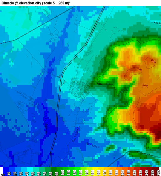
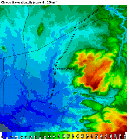
Below is the Elevation map of Olmedo, which displays elevation range with different colors. Scale of the first map is from 5 to 265 m (16 to 869 ft) with average elevation of 66.5 meters (=218 ft) [note 1]
These maps also provides idea of topography and contour of this city, they are displayed at different zoom levels. More info about maps, scale and edge coordinates you can find below images.
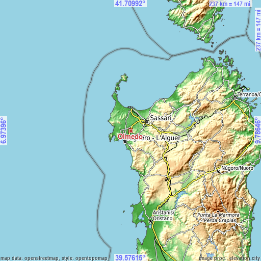
| \ | Map #1 | Map #2 | Topo.Map |
| Scale [m] | 5..265 m | -2..266 m | × |
| Scale [ft] | 16..869 ft | -7..873 ft | × |
| Average | 66.5 m = 218 ft | 65.4 m = 215 ft | × |
| Width | 7.41 km = 4.6 mi | 14.83 km = 9.2 mi | 237.3 km = 147.5 mi |
| Height | 7.41 km = 4.6 mi | 14.83 km = 9.2 mi | 237.2 km = 147.4 mi |
| ↑Max Latitude | 40.684892° | 40.718208° | 41.70992° |
| Latitude at center | 40.65156° | 40.65156° | 40.65156° |
| ↓Min Latitude | 40.618211° | 40.584845° | 39.57615° |
| ← Min Longitude | 8.336265° | 8.292319° | 6.97396° |
| Longitude center | 8.38021° | 8.38021° | 8.38021° |
| →Max Longitude | 8.424155° | 8.468101° | 9.78646° |
Nearby cities:
Cities around Olmedo sort by population:
• Sassari elevation 190 m
16.9 km,  60°
60°
• Alghero 18 m
11.4 km,  206°
206°
• Li Punti-San Giovanni 89 m
15.4 km,  36°
36°
• Ittiri 393 m
17.3 km,  112°
112°
• Ossi 321 m
18.1 km,  81°
81°
• Usini 201 m
13.5 km, 84°
• Uri 168 m
9.3 km,  99°
99°
• Villanova Monteleone 573 m
18.3 km,  155°
155°
• Tissi 239 m
15.6 km, 78°
• Ottava 70 m
16.9 km,  28°
28°
• Bancali 84 m
11.7 km, 36°
• Putifigari 270 m
12.1 km,  145°
145°
Multilingual:
 En español:
Olmedo elevación 57 m.
 En France:
Olmedo élévation 57 m.


Sources and notes:
- [note 1] Map square and city borders are not equal. Map elevation data is calculated only from area inside that square.
- [src 1] Elevation data from geonames database provided with same terms of usage.
- [src 2] The elevation map of Olmedo is generated using elevation data from NASA's 3 arcsec (90m) resolution SRTM data.
- [src 3] Base (background) map © OpenStreetMap contributors tiles are generated by Geofabrik and OpenTopoMap.
Copyright & License:
This Olmedo Elevation Map is licensed under CC BY-SA. You may reuse any part from this page, if you give a proper credit by linking to this URL:
 More info on terms of use page.