Panni elevation
Panni (Apulia, Provincia di Foggia), Italy elevation is 731 meters and Panni elevation in feet is 2398 ft above sea level [src 1]. Panni is a seat of a third-order administrative division (feature code) with elevation that is 409 meters (1342 ft) bigger than average city elevation in Italy.
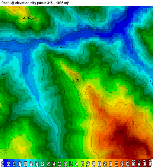
Below is the Elevation map of Panni, which displays elevation range with different colors. Scale of the first map is from 318 to 1095 m (1043 to 3593 ft) with average elevation of 602.6 meters (=1977 ft) [note 1]
These maps also provides idea of topography and contour of this city, they are displayed at different zoom levels. More info about maps, scale and edge coordinates you can find below images.
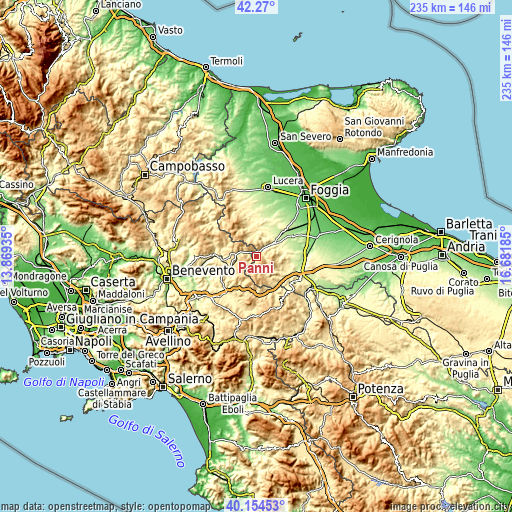
| \ | Map #1 | Topo.Map |
| Scale [m] | 318..1095 m | × |
| Scale [ft] | 1043..3593 ft | × |
| Average | 602.6 m = 1977 ft | × |
| Width | 7.35 km = 4.6 mi | 235.2 km = 146.1 mi |
| Height | 7.35 km = 4.6 mi | 235.2 km = 146.1 mi |
| ↑Max Latitude | 41.253866° | 42.27° |
| Latitude at center | 41.22082° | 41.22082° |
| ↓Min Latitude | 41.187757° | 40.15453° |
| ← Min Longitude | 15.231655° | 13.86935° |
| Longitude center | 15.2756° | 15.2756° |
| →Max Longitude | 15.319545° | 16.68185° |
Nearby cities:
Cities around Panni sort by population:
• Deliceto elevation 600 m
9.1 km,  88°
88°
• Bovino 601 m
6.2 km,  59°
59°
• Orsara di Puglia 683 m
6.8 km,  354°
354°
• Accadia 652 m
8.4 km,  146°
146°
• Sant'Agata di Puglia 759 m
11.6 km,  131°
131°
• Anzano di Puglia 792 m
11.1 km,  175°
175°
• Monteleone di Puglia 841 m
6.1 km,  193°
193°
• Savignano Irpino 667 m
8.1 km,  274°
274°
• Zungoli 670 m
12 km,  210°
210°
• Greci 794 m
9.5 km,  291°
291°
• Montaguto 717 m
3.8 km,  323°
323°
• Celle di San Vito 727 m
14.1 km,  325°
325°
Multilingual:
 En español:
Panni elevación 731 m.
 En France:
Panni élévation 731 m.


Sources and notes:
- [note 1] Map square and city borders are not equal. Map elevation data is calculated only from area inside that square.
- [src 1] Elevation data from geonames database provided with same terms of usage.
- [src 2] The elevation map of Panni is generated using elevation data from NASA's 3 arcsec (90m) resolution SRTM data.
- [src 3] Base (background) map © OpenStreetMap contributors tiles are generated by Geofabrik and OpenTopoMap.
Copyright & License:
This Panni Elevation Map is licensed under CC BY-SA. You may reuse any part from this page, if you give a proper credit by linking to this URL:
 More info on terms of use page.