Pergola elevation
Pergola (The Marches, Provincia di Pesaro e Urbino), Italy elevation is 276 meters and Pergola elevation in feet is 906 ft above sea level [src 1]. Pergola is a seat of a third-order administrative division (feature code) with elevation that is 46 meters (151 ft) smaller than average city elevation in Italy.
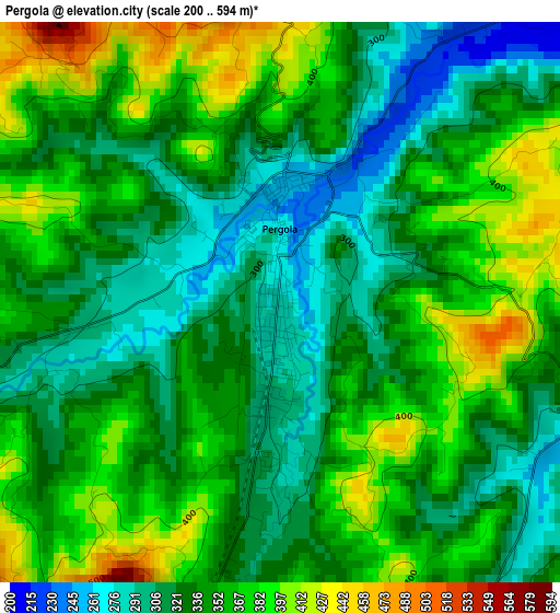
Below is the Elevation map of Pergola, which displays elevation range with different colors. Scale of the first map is from 200 to 594 m (656 to 1949 ft) with average elevation of 344.6 meters (=1131 ft) [note 1]
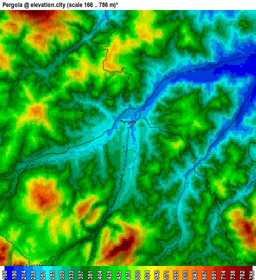
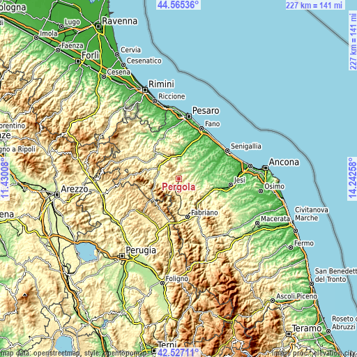
These maps also provides idea of topography and contour of this city, they are displayed at different zoom levels. More info about maps, scale and edge coordinates you can find below images.
| \ | Map #1 | Map #2 | Topo.Map |
| Scale [m] | 200..594 m | 166..786 m | × |
| Scale [ft] | 656..1949 ft | 545..2579 ft | × |
| Average | 344.6 m = 1131 ft | 393.2 m = 1290 ft | × |
| Width | 7.08 km = 4.4 mi | 14.16 km = 8.8 mi | 226.6 km = 140.8 mi |
| Height | 7.08 km = 4.4 mi | 14.16 km = 8.8 mi | 226.6 km = 140.8 mi |
| ↑Max Latitude | 43.586689° | 43.618512° | 44.56536° |
| Latitude at center | 43.55485° | 43.55485° | 43.55485° |
| ↓Min Latitude | 43.522994° | 43.491121° | 42.52711° |
| ← Min Longitude | 12.792385° | 12.748439° | 11.43008° |
| Longitude center | 12.83633° | 12.83633° | 12.83633° |
| →Max Longitude | 12.880275° | 12.924221° | 14.24258° |
Nearby cities:
Cities around Pergola sort by population:
• Cagli elevation 249 m
14.9 km,  266°
266°
• Sassoferrato 284 m
13.9 km,  173°
173°
• Acqualagna 205 m
15.1 km,  301°
301°
• San Lorenzo in Campo 174 m
10.1 km,  59°
59°
• Arcevia 416 m
10.6 km,  123°
123°
• Castelleone di Suasa 201 m
12.9 km, 62°
• Osteria 138 m
15 km,  92°
92°
• Frontone 397 m
9.1 km,  240°
240°
• Barchi 319 m
15.1 km,  29°
29°
• Fratte Rosa 403 m
10.2 km, 31°
• Sant'Ippolito 256 m
14.2 km,  12°
12°
• Serra Sant'Abbondio 509 m
8.6 km,  215°
215°
Multilingual:
 En español:
Pergola elevación 276 m.
 En France:
Pergola élévation 276 m.


Sources and notes:
- [note 1] Map square and city borders are not equal. Map elevation data is calculated only from area inside that square.
- [src 1] Elevation data from geonames database provided with same terms of usage.
- [src 2] The elevation map of Pergola is generated using elevation data from NASA's 3 arcsec (90m) resolution SRTM data.
- [src 3] Base (background) map © OpenStreetMap contributors tiles are generated by Geofabrik and OpenTopoMap.
Copyright & License:
This Pergola Elevation Map is licensed under CC BY-SA. You may reuse any part from this page, if you give a proper credit by linking to this URL:
 More info on terms of use page.