Piana Crixia elevation
Piana Crixia (Liguria, Provincia di Savona), Italy elevation is 270 meters and Piana Crixia elevation in feet is 886 ft above sea level [src 1]. Piana Crixia is a seat of a third-order administrative division (feature code) with elevation that is 52 meters (171 ft) smaller than average city elevation in Italy.
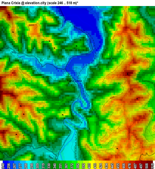
Below is the Elevation map of Piana Crixia, which displays elevation range with different colors. Scale of the first map is from 246 to 518 m (807 to 1699 ft) with average elevation of 365.7 meters (=1200 ft) [note 1]
These maps also provides idea of topography and contour of this city, they are displayed at different zoom levels. More info about maps, scale and edge coordinates you can find below images.
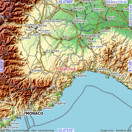
| \ | Map #1 | Topo.Map |
| Scale [m] | 246..518 m | × |
| Scale [ft] | 807..1699 ft | × |
| Average | 365.7 m = 1200 ft | × |
| Width | 6.97 km = 4.3 mi | 223.1 km = 138.6 mi |
| Height | 6.97 km = 4.3 mi | 223.1 km = 138.6 mi |
| ↑Max Latitude | 44.516384° | 45.47968° |
| Latitude at center | 44.48504° | 44.48504° |
| ↓Min Latitude | 44.45368° | 43.47315° |
| ← Min Longitude | 8.264105° | 6.9018° |
| Longitude center | 8.30805° | 8.30805° |
| →Max Longitude | 8.351995° | 9.7143° |
Nearby cities:
Cities around Piana Crixia sort by population:
• Cairo Montenotte elevation 330 m
10 km,  193°
193°
• Dego 303 m
4.5 km,  180°
180°
• Spigno Monferrato 253 m
6.8 km,  17°
17°
• Mioglia 345 m
8.5 km,  84°
84°
• Molino-Pera 287 m
0.3 km,  12°
12°
• Castelletto Uzzone 394 m
9.6 km,  276°
276°
• Pareto 456 m
6.8 km,  59°
59°
• Mombaldone 219 m
9.7 km, 11°
• Giusvalla 454 m
8 km,  121°
121°
• Merana 252 m
3.8 km,  348°
348°
• Pezzolo Valle Uzzone 311 m
10.8 km,  303°
303°
• Serole 601 m
8.6 km,  333°
333°
Multilingual:
 En español:
Piana Crixia elevación 270 m.
 En France:
Piana Crixia élévation 270 m.
 Auf Deutsch:
Piana Crixia höhe über dem Meeresspiegel ist 270 m.

Sources and notes:
- [note 1] Map square and city borders are not equal. Map elevation data is calculated only from area inside that square.
- [src 1] Elevation data from geonames database provided with same terms of usage.
- [src 2] The elevation map of Piana Crixia is generated using elevation data from NASA's 3 arcsec (90m) resolution SRTM data.
- [src 3] Base (background) map © OpenStreetMap contributors tiles are generated by Geofabrik and OpenTopoMap.
Copyright & License:
This Piana Crixia Elevation Map is licensed under CC BY-SA. You may reuse any part from this page, if you give a proper credit by linking to this URL:
 More info on terms of use page.